
File:New Zealand House, Haymarket, London.jpg
Size of this preview: 417 × 600 pixels. Other resolutions: 167 × 240 pixels | 445 × 640 pixels.
Original file (445 × 640 pixels, file size: 176 KB, MIME type: image/jpeg)
| This is a file from the Wikimedia Commons. Information from its description page there is shown below. Commons is a freely licensed media file repository. You can help. |
Summary
| Description |
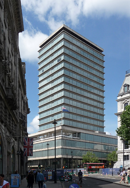
English: A much feted Modernist building, one of the early examples of a tower resting on a broad, low podium (1957-63). It has a reinforced concrete frame clad in Portland stone, except for the ground floor which is clad in black Belgian marble recessed behind stainless-steel-clad pilotis. Between the floors of the tower are slight stone projections. The architects were Robert Matthew, Johnson-Marshall & Partners. It now belongs to a very exclusive club of post-war buildings: Grade II listed.
Fittingly, it houses the New Zealand High Commission. |
| Date | |
| Source | https://www.geograph.org.uk/photo/2668178 |
| Author | Stephen Richards |
| Attribution (required by the license) | Stephen Richards / New Zealand House, Haymarket / |
| Camera location | | View this and other nearby images on: OpenStreetMap |
|---|
_heading:292.00&language=en)
| Object location | | View this and other nearby images on: OpenStreetMap |
|---|
_heading:292.00&language=en)
Licensing

|
This image was taken from the Geograph project collection. See this photograph's page on the Geograph website for the photographer's contact details. The copyright on this image is owned by Stephen Richards and is licensed for reuse under the Creative Commons Attribution-ShareAlike 2.0 license.
|
This file is licensed under the Creative Commons Attribution-Share Alike 2.0 Generic license.
Attribution: Stephen Richards
- You are free:
- to share – to copy, distribute and transmit the work
- to remix – to adapt the work
- Under the following conditions:
- attribution – You must give appropriate credit, provide a link to the license, and indicate if changes were made. You may do so in any reasonable manner, but not in any way that suggests the licensor endorses you or your use.
- share alike – If you remix, transform, or build upon the material, you must distribute your contributions under the same or compatible license as the original.
File history
Click on a date/time to view the file as it appeared at that time.
| Date/Time | Thumbnail | Dimensions | User | Comment | |
|---|---|---|---|---|---|
| current | 08:23, 4 July 2013 | | 445 × 640 (176 KB) | Ham II | User created page with UploadWizard |
File usage
The following pages on the English Wikipedia use this file (pages on other projects are not listed):
Global file usage
The following other wikis use this file:
- Usage on af.wikipedia.org
- Usage on da.wikipedia.org
- Usage on de.wikipedia.org
- Usage on en.wikivoyage.org
- Usage on es.wikipedia.org
- Usage on fr.wikipedia.org
- Usage on gl.wikipedia.org
- Usage on ko.wikipedia.org
- Usage on pt.wikipedia.org
- Usage on www.wikidata.org
- Usage on zh.wikipedia.org