
File:Northmavine Shetland UK parish map (blank).svg

Size of this PNG preview of this SVG file: 315 × 599 pixels. Other resolutions: 126 × 240 pixels | 252 × 480 pixels | 404 × 768 pixels | 538 × 1,024 pixels | 1,077 × 2,048 pixels | 832 × 1,582 pixels.
Original file (SVG file, nominally 832 × 1,582 pixels, file size: 1.5 MB)
| This is a file from the Wikimedia Commons. Information from its description page there is shown below. Commons is a freely licensed media file repository. You can help. |
.svg)
Summary
| Description |
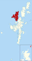
English: Blank map of the Shetland Islands, UK with parishes shown.
Equirectangular map projection on WGS 84 datum, with N/S stretched 200% Geographic limits:
|
| Date | |
| Source | File:Shetland_UK_parish_map_(blank).svg |
| Author | Nilfanion, created using Ordnance Survey data. Northmavine highlighted by Griceylipper |
.svg)
Licensing
This file is licensed under the Creative Commons Attribution-Share Alike 3.0 Unported license.
Attribution: Contains Ordnance Survey data © Crown copyright and database right 2013
Contains NRS data © Crown copyright and database right 2013
Contains NRS data © Crown copyright and database right 2013
- You are free:
- to share – to copy, distribute and transmit the work
- to remix – to adapt the work
- Under the following conditions:
- attribution – You must give appropriate credit, provide a link to the license, and indicate if changes were made. You may do so in any reasonable manner, but not in any way that suggests the licensor endorses you or your use.
- share alike – If you remix, transform, or build upon the material, you must distribute your contributions under the same or compatible license as the original.
File history
Click on a date/time to view the file as it appeared at that time.
| Date/Time | Thumbnail | Dimensions | User | Comment | |
|---|---|---|---|---|---|
| current | 18:19, 10 May 2020 | | 832 × 1,582 (1.5 MB) | Griceylipper | Uploaded a work by Nilfanion, created using Ordnance Survey data. Northmavine highlighted by Griceylipper from https://commons.wikimedia.org/wiki/File:Shetland_UK_parish_map_(blank).svg with UploadWizard |
File usage
The following pages on the English Wikipedia use this file (pages on other projects are not listed):
Global file usage
The following other wikis use this file:
- Usage on ca.wikipedia.org
- Usage on de.wikivoyage.org
- Usage on eu.wikipedia.org
- Usage on pl.wikipedia.org
- Usage on www.wikidata.org
.svg)