
File:OGC WCS Suite, Logical Suite.png
Size of this preview: 772 × 599 pixels. Other resolutions: 309 × 240 pixels | 618 × 480 pixels | 989 × 768 pixels | 1,109 × 861 pixels.
Original file (1,109 × 861 pixels, file size: 55 KB, MIME type: image/png)
| This is a file from the Wikimedia Commons. Information from its description page there is shown below. Commons is a freely licensed media file repository. You can help. |
Summary
| Description |
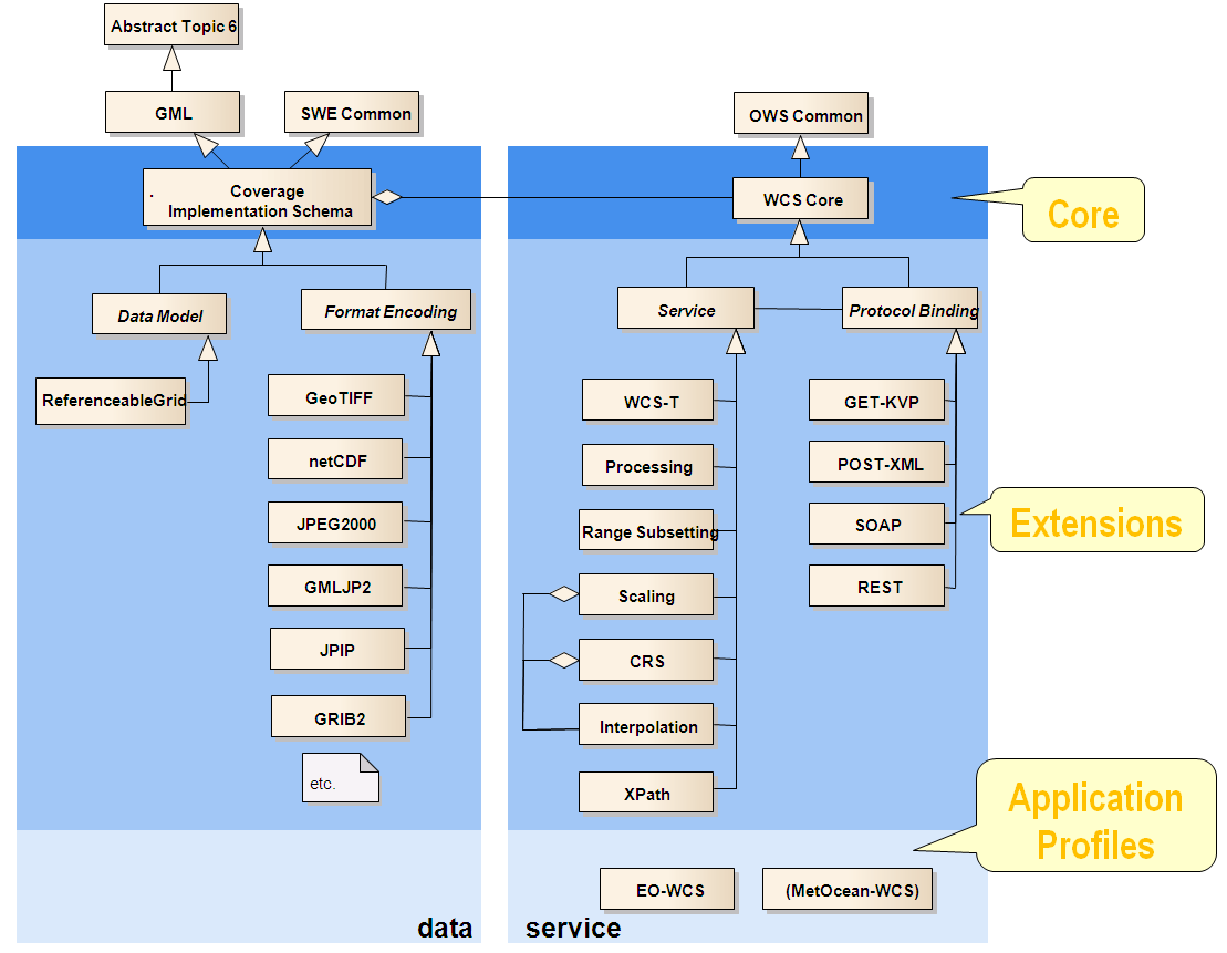
English: The Open Geospatial Consortium (OGC) Web Coverage Service (WCS) standard consists of a Core and several Extensions. This UML diagram shows Core and Extensions, as well as dependencies between them an on other OGC standards. |
| Date | |
| Source |
Enterprise Architect |
| Author | Pebau.grandauer |
Licensing
I, the copyright holder of this work, hereby publish it under the following licenses:

|
Permission is granted to copy, distribute and/or modify this document under the terms of the GNU Free Documentation License, Version 1.2 or any later version published by the Free Software Foundation; with no Invariant Sections, no Front-Cover Texts, and no Back-Cover Texts. A copy of the license is included in the section entitled GNU Free Documentation License. |
This file is licensed under the Creative Commons Attribution-Share Alike 3.0 Unported license.
- You are free:
- to share – to copy, distribute and transmit the work
- to remix – to adapt the work
- Under the following conditions:
- attribution – You must give appropriate credit, provide a link to the license, and indicate if changes were made. You may do so in any reasonable manner, but not in any way that suggests the licensor endorses you or your use.
- share alike – If you remix, transform, or build upon the material, you must distribute your contributions under the same or compatible license as the original.
You may select the license of your choice.
File history
Click on a date/time to view the file as it appeared at that time.
| Date/Time | Thumbnail | Dimensions | User | Comment | |
|---|---|---|---|---|---|
| current | 16:39, 14 November 2017 | | 1,109 × 861 (55 KB) | Pebau.grandauer | This file gives a UML-style overview on the modular [Web_Coverage_Service | OGC Web Coverage Service]]] standards suite, separated into data and service model. The diagram has been updated by the creator and standards editor to reflect OGC's... |
| 07:00, 8 April 2014 |  | 834 × 573 (82 KB) | Pebau.grandauer | updated because (i) recently all service specs have been adopted, so there is no use any longer in differentiating visually; (ii) presentation has been made easier to understand by showing core, extensions, and profiles with different background colors. | |
| 15:58, 8 September 2013 |  | 1,180 × 817 (44 KB) | Pebau.grandauer | updated to new structuring, based on recent (2013) work with in OGC Web Coverage Service Standards Working Group (WCS.SWG). | |
| 08:07, 11 July 2012 |  | 856 × 684 (32 KB) | Pebau.grandauer | {{subst:Upload marker added by en.wp UW}} {{Information |Description = {{en|The Open Geospatial Consortium (OGC) Web Coverage Service (WCS) standard consists of a Core and several Extensions. This UML diagram shows Core and Extensions, as well as depen... |
File usage
The following pages on the English Wikipedia use this file (pages on other projects are not listed):
Global file usage
The following other wikis use this file:
- Usage on de.wikipedia.org