
File:Omulyakhskaya and Khromskaya Bays, Northern Siberia.jpg

Size of this preview: 800 × 533 pixels. Other resolutions: 320 × 213 pixels | 640 × 427 pixels | 1,024 × 683 pixels | 1,280 × 853 pixels | 2,560 × 1,707 pixels | 4,696 × 3,131 pixels.
Original file (4,696 × 3,131 pixels, file size: 4.69 MB, MIME type: image/jpeg)
| This is a file from the Wikimedia Commons. Information from its description page there is shown below. Commons is a freely licensed media file repository. You can help. |
Summary
| Description |
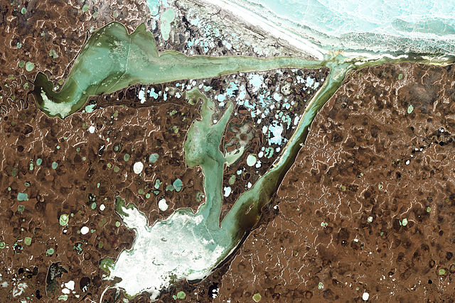
English: Natural-colour image of the Omulyakhskaya and Khromskaya Bays, Russia. The land around the bays is dotted with thermokarst lakes, which result from water released by thawing permafrost. The water in a thermokarst lake doesn’t always stay put; these lakes can melt through the surrounding permafrost and drain into a nearby water body, especially if it sits at a slightly lower elevation. This appears to have occurred in multiple lakes between the bays shown above. (The compound lakes are identifiable by their uneven margins.) Coastal erosion and river migration also can deplete the lakes. Dark brown spots, especially numerous east of Khromskaya Bay, are probably locations of former thermokarst lakes.
Image captured by the Thematic Mapper on the Landsat 5 satellite. Landsat data provided by the United States Geological Survey. Français : Image en couleurs naturelles des baies d’Omulyakhskaya et de Khromskaya (Russie). On distingue autour de ces baies une constellation de lacs thermokarstiques, résultant de l'eau libérée par le dégel du pergélisol. L’eau d’un lac thermokarst peut brutalement disparaitre à travers le pergélisol environnant et se déverser dans un plan d'eau voisin, surtout s'il se trouve à une altitude légèrement inférieure. Cela semble s'être produit dans plusieurs de slacs situés sur cette image (Les lacs composés sont identifiables par leurs marges inégales.) L'érosion côtière et la migration des rivières peuvent aussi vider des lacs. Les taches brun foncé, particulièrement nombreuses à l'est de la baie de Khromskaya, sont probablement des emplacements d'anciens lacs thermokarstiques. Image capturée par le Thematic Mapper sur le satellite Landsat 5. Données Landsat fournies par le United States Geological Survey. |
| Date | |
| Source | NASA Earth Observatory |
| Author | Jesse Allen and Robert Simmon |
| Other versions |
Licensing
| This file is in the public domain in the United States because it was solely created by NASA. NASA copyright policy states that "NASA material is not protected by copyright unless noted". (See Template:PD-USGov, NASA copyright policy page or JPL Image Use Policy.) | ||
 |
Warnings:
|
| Annotations | This image is annotated: View the annotations at Commons |
File history
Click on a date/time to view the file as it appeared at that time.
| Date/Time | Thumbnail | Dimensions | User | Comment | |
|---|---|---|---|---|---|
| current | 13:39, 14 August 2011 | | 4,696 × 3,131 (4.69 MB) | Originalwana | {{Information |Description ={{en|1=Natural-colour image of the Omulyakhskaya and Khromskaya Bays. The land around the bays is dotted with thermokarst lakes, which result from water released by thawing permafrost. The water |
File usage
The following pages on the English Wikipedia use this file (pages on other projects are not listed):
Global file usage
The following other wikis use this file:
- Usage on arz.wikipedia.org
- Usage on be.wikipedia.org
- Usage on bg.wikipedia.org
- Usage on ceb.wikipedia.org
- Usage on cs.wikipedia.org
- Usage on de.wikipedia.org
- Usage on es.wikipedia.org
- Usage on fa.wikipedia.org
- Usage on it.wikipedia.org
- Usage on pl.wikipedia.org
- Usage on tr.wikipedia.org
- Usage on uk.wikipedia.org
- Usage on www.wikidata.org