
File:Pascatway River New England.jpg
Original file (3,440 × 2,448 pixels, file size: 749 KB, MIME type: image/jpeg)
| This is a file from the Wikimedia Commons. Information from its description page there is shown below. Commons is a freely licensed media file repository. You can help. |
Summary
| Description |
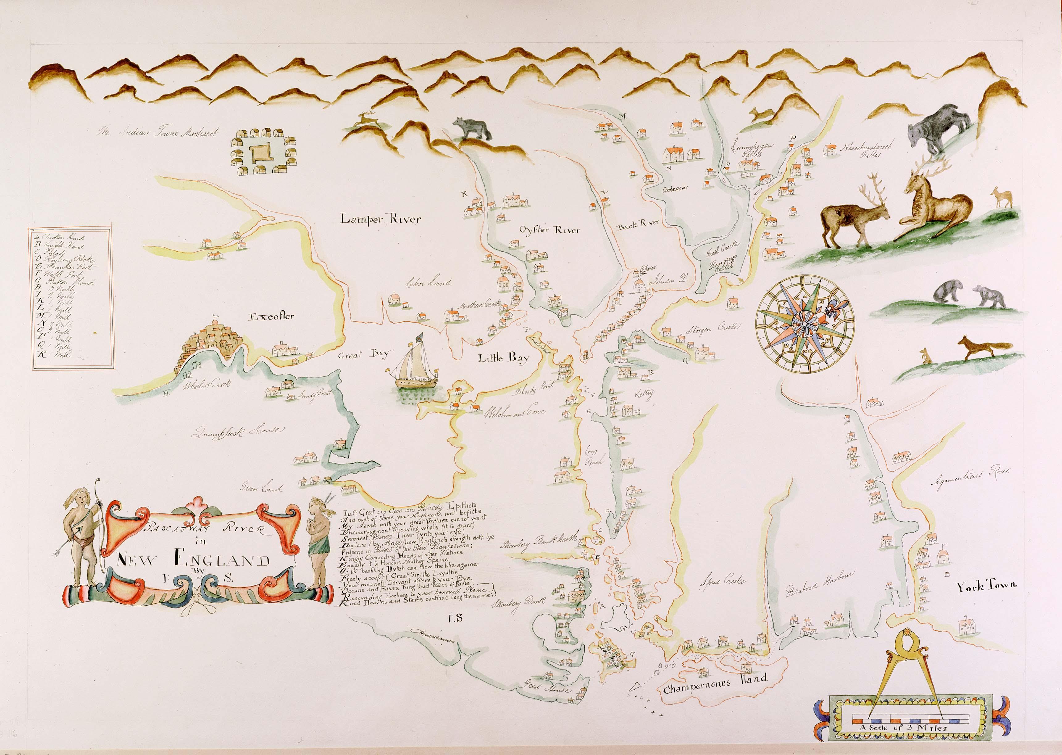
English: Maine historian James Phinney Baxter commissioned the map to be copied from the original in the late 19th century. The original surveyor and creator of the map is unknown, except that the original map carries the initials 'J.S.' from its creator. The map was apparently created during the tenure of King Charles II of England's brother James as the Duke of York, which places its creation sometime around 1670. The map shows the region of the Piscataqua River. Courtesy of the Maine State Archives. Retouched by MarmadukePercy |
| Date | circa 1670 |
| Source | http://www.mainememory.net/bin/Detail?ln=6665 |
| Author | Unknown author(initials j.s.) |
Licensing
|
This work is in the public domain in its country of origin and other countries and areas where the copyright term is the author's life plus 70 years or fewer.
| |
| This file has been identified as being free of known restrictions under copyright law, including all related and neighboring rights. | |
File history
Click on a date/time to view the file as it appeared at that time.
| Date/Time | Thumbnail | Dimensions | User | Comment | |
|---|---|---|---|---|---|
| current | 12:28, 7 March 2010 | | 3,440 × 2,448 (749 KB) | Justass | resolution |
| 22:58, 5 March 2010 |  | 500 × 334 (91 KB) | MarmadukePercy | {{Information |Description={{en|1=Maine historian James Phinney Baxter commissioned the map to be copied from the original in the late 19th century. The original surveyor and creator of the map is unknown, except that the original map carries the initials |
File usage
Global file usage
The following other wikis use this file:
- Usage on arz.wikipedia.org
- Usage on es.wikipedia.org
- Usage on ga.wikipedia.org
- Usage on hu.wikipedia.org
- Usage on ko.wikipedia.org
- Usage on la.wikipedia.org
- Usage on sr.wikipedia.org
- Usage on uk.wikipedia.org