
File:Perspective view of makai elevation, looking ewa-mauka - Washington Place, 320 South Beretania Street, Honolulu, Honolulu County, HI HABS HI,2-HONLU,28-40.tif

Size of this JPG preview of this TIF file: 800 × 578 pixels. Other resolutions: 320 × 231 pixels | 640 × 463 pixels | 1,024 × 740 pixels | 1,280 × 925 pixels | 2,560 × 1,851 pixels | 5,320 × 3,846 pixels.
Original file (5,320 × 3,846 pixels, file size: 19.52 MB, MIME type: image/tiff)
| This is a file from the Wikimedia Commons. Information from its description page there is shown below. Commons is a freely licensed media file repository. You can help. |
Summary
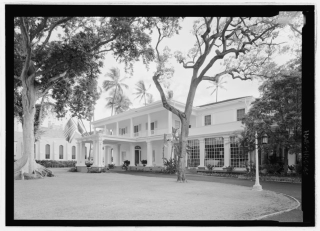
| Perspective view of makai elevation, looking ewa-mauka - Washington Place, 320 South Beretania Street, Honolulu, Honolulu County, HI | ||||
|---|---|---|---|---|
| Photographer |
Rosenthal, James W. Related names:
|
|||
| Title |
Perspective view of makai elevation, looking ewa-mauka - Washington Place, 320 South Beretania Street, Honolulu, Honolulu County, HI |
|||
| Depicted place | Hawaii; Honolulu County; Honolulu | |||
| Date | 2007 | |||
| Dimensions | 5 x 7 in. | |||
| Current location |
Library of Congress Prints and Photographs Division Washington, D.C. 20540 USA http://hdl.loc.gov/loc.pnp/pp.print |
|||
| Accession number |
HABS HI,2-HONLU,28-40 |
|||
| Credit line |
|
|||
| Notes |
|
|||
| References |
|
|||
| Source | https://www.loc.gov/pictures/item/hi0023.photos.225498p | |||
| Permission (Reusing this file) |
|
|||

| Camera location | | View this and other nearby images on: OpenStreetMap |
|---|
File history
Click on a date/time to view the file as it appeared at that time.
| Date/Time | Thumbnail | Dimensions | User | Comment | |
|---|---|---|---|---|---|
| current | 17:23, 15 July 2014 |  | 5,320 × 3,846 (19.52 MB) | Fæ | GWToolset: Creating mediafile for Fæ. HABS 09 July 2014 (801:1000) |
File usage
No pages on the English Wikipedia use this file (pages on other projects are not listed).
Global file usage
The following other wikis use this file:
- Usage on hy.wikipedia.org