
File:Pizzigani brothers 1367 map (Atlantic detail).jpg
No higher resolution available.
Pizzigani_brothers_1367_map_(Atlantic_detail).jpg (515 × 497 pixels, file size: 23 KB, MIME type: image/jpeg)
| This is a file from the Wikimedia Commons. Information from its description page there is shown below. Commons is a freely licensed media file repository. You can help. |
.jpg)
Summary
| Description |
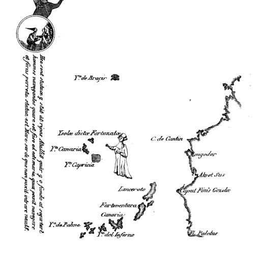
English: Detail of the Atlantic islands off the African coast in the 1367 portolan chart of the Pizzigani brothers (Domenico and Francesco Pizzigano) of Venice, as reproduced in the 1849 sketch of Edmé François Jomard (1777-1862). This detail depicts the Canary islands and the fictional cluster of St. Brendan. |
| Date | |
| Source | Magasin pittoresque, 1849 |
| Author | Domenico and Francesco Pizzigani |
Licensing
|
This work is in the public domain in its country of origin and other countries and areas where the copyright term is the author's life plus 100 years or fewer. | |
| This file has been identified as being free of known restrictions under copyright law, including all related and neighboring rights. | |
File history
Click on a date/time to view the file as it appeared at that time.
| Date/Time | Thumbnail | Dimensions | User | Comment | |
|---|---|---|---|---|---|
| current | 15:50, 15 June 2011 | | 515 × 497 (23 KB) | Walrasiad | {{Information |Description ={{en|1=Detail of the Atlantic islands off the African coast in the 1367 portolan chart of the Pizzigani brothers (Domenico and Francesco Pizzigano) of Venice, as reproduced in the 1849 sketch of Edmé François Jomard (1777- |
File usage
The following pages on the English Wikipedia use this file (pages on other projects are not listed):
Global file usage
The following other wikis use this file:
- Usage on fr.wikipedia.org
- Usage on ja.wikipedia.org
- Usage on ka.wikipedia.org
- Usage on uk.wikipedia.org
.jpg)