
File:Plan métro tramway Toulouse.svg

Size of this PNG preview of this SVG file: 799 × 599 pixels. Other resolutions: 320 × 240 pixels | 640 × 480 pixels | 1,024 × 768 pixels | 1,280 × 960 pixels | 2,560 × 1,920 pixels | 2,237 × 1,678 pixels.
Original file (SVG file, nominally 2,237 × 1,678 pixels, file size: 351 KB)
| This is a file from the Wikimedia Commons. Information from its description page there is shown below. Commons is a freely licensed media file repository. You can help. |
Summary
| Description |
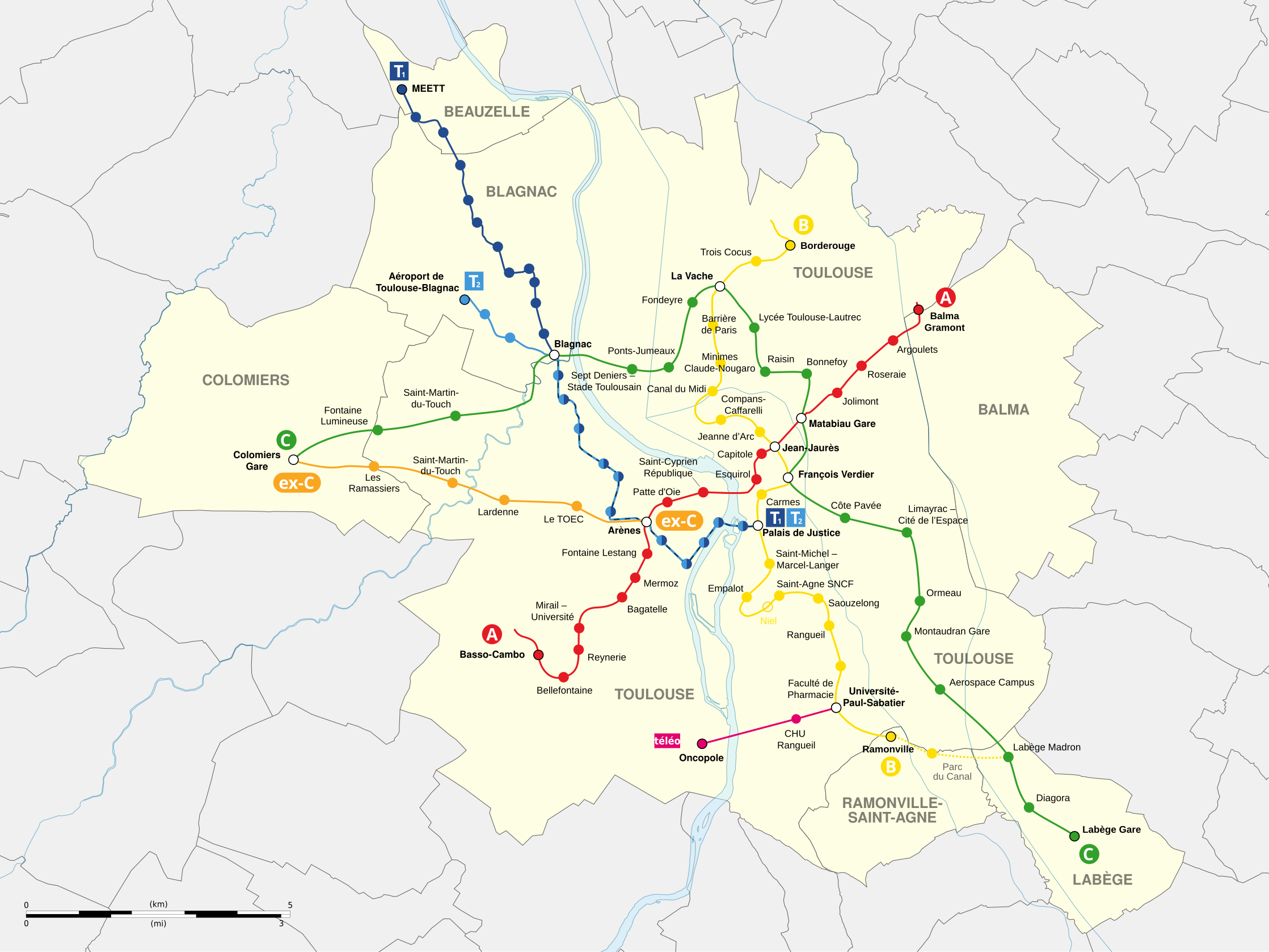
English: Map of subway and tramway lines of Toulouse, France.
Line A (metro)
Line B (metro
Line B extension project
Ex-line C (urban train)
Line C project (metro)
T1 (tramway)
T2 (tramway)
Téléo South urban aerial tramway Français : Carte des lignes de métro et de tramways de Toulouse, France.
Ligne A (métro)
Ligne B (métro)
Projet d'extension de la ligne B
ex-Ligne C (train urbain)
Projet de ligne C du métro de Toulouse
T1 (tram)
T2 (tram)
|
| Date | (UTC) |
| Source |
English: Transport lines, communes and rivers: OpenStreetMap (CC-BY-SA-2.0)
Français : Tracé des lignes, communes et rivières : OpenStreetMap (CC-BY-SA-2.0) |
| Author | |
| Attribution (required by the license) | © Sémhur / Wikimedia Commons / |
| SVG development |
| Object location | | View this and other nearby images on: OpenStreetMap |
|---|
Licensing
I, the copyright holder of this work, hereby publish it under the following licenses:
| Copyleft: This work of art is free; you can redistribute it and/or modify it according to terms of the Free Art License. You will find a specimen of this license on the Copyleft Attitude site as well as on other sites. |
This file is licensed under the Creative Commons Attribution-Share Alike 4.0 International, 3.0 Unported, 2.5 Generic, 2.0 Generic and 1.0 Generic license.
- You are free:
- to share – to copy, distribute and transmit the work
- to remix – to adapt the work
- Under the following conditions:
- attribution – You must give appropriate credit, provide a link to the license, and indicate if changes were made. You may do so in any reasonable manner, but not in any way that suggests the licensor endorses you or your use.
- share alike – If you remix, transform, or build upon the material, you must distribute your contributions under the same or compatible license as the original.
You may select the license of your choice.
File history
Click on a date/time to view the file as it appeared at that time.
| Date/Time | Thumbnail | Dimensions | User | Comment | |
|---|---|---|---|---|---|
| current | 20:10, 10 May 2023 | | 2,237 × 1,678 (351 KB) | Sémhur | 8 noms modifiés sur la ligne C |
| 21:13, 8 February 2023 |  | 2,237 × 1,678 (351 KB) | Sémhur | Grande partie des noms définitifs | |
| 16:17, 18 December 2022 |  | 2,237 × 1,678 (346 KB) | Sémhur | La future ligne TAE devient la future ligne C. L'ancienne "ligne C" n'a pas encore de nom. | |
| 19:05, 15 May 2022 |  | 2,237 × 1,678 (362 KB) | Sémhur | 15 - Mise en service de Téléo | |
| 12:16, 27 August 2021 |  | 2,237 × 1,678 (363 KB) | Dams W | + Ajout logo téléochangement de couleur (d'après dernier communiqué de presse de Tisséo https://www.tisseo.fr/sites/default/files/cp/Mise_en_circulation_des_cabines_de_Teleo_def_28072021.pdf) | |
| 20:22, 30 May 2021 |  | 2,237 × 1,678 (361 KB) | Sémhur | + MEETT | |
| 20:26, 9 December 2020 |  | 2,237 × 1,678 (361 KB) | Sémhur | 12 - Ajout du téléphérique Téléo | |
| 20:17, 6 August 2018 |  | 2,237 × 1,678 (359 KB) | Sémhur | 11 - Mise à jour des noms du TAE à partir du dernier comité syndical de Tisséo du 11 juillet 2018 : https://pbs.twimg.com/media/Dhz-3orXUAA-CGJ.jpg | |
| 19:46, 15 July 2018 |  | 2,237 × 1,678 (361 KB) | Sémhur | Ajout station Fondeyre | |
| 20:31, 22 August 2017 |  | 2,237 × 1,678 (367 KB) | Sémhur | 9 - Déplacement de la station "Montaudran Innovation Campus Airbus Defence & Space" |
File usage
The following pages on the English Wikipedia use this file (pages on other projects are not listed):
Global file usage
The following other wikis use this file:
- Usage on de.wikipedia.org
- Usage on eo.wikipedia.org
- Usage on fr.wikipedia.org
- Liste des métros en France
- LGV Bordeaux - Toulouse
- Transports en commun de Toulouse
- Métro de Toulouse
- Ligne A du métro de Toulouse
- Ligne B du métro de Toulouse
- Ligne C du métro de Toulouse
- Téléphérique de Toulouse
- Wikipédia:Atelier graphique/Cartes/Archives/janvier 2016
- Wikipédia:Atelier graphique/Cartes/Archives/juillet 2017
- Wikipédia:Atelier graphique/Cartes/Archives/juillet 2018
- Toulouse Aerospace Express
- Usage on it.wikivoyage.org
- Usage on nl.wikipedia.org
- Usage on oc.wikipedia.org
- Usage on www.wikidata.org
- Usage on zh.wikipedia.org