
File:Plan of St. Lucia, in the West Indies- Shewing the positions of the English and French forces with the attacks made at its reduction in Decr. 1778. LOC 74696150.jpg

Size of this preview: 800 × 598 pixels. Other resolutions: 320 × 239 pixels | 640 × 479 pixels | 1,024 × 766 pixels | 1,280 × 957 pixels | 2,560 × 1,915 pixels | 3,107 × 2,324 pixels.
Original file (3,107 × 2,324 pixels, file size: 3.17 MB, MIME type: image/jpeg)
| This is a file from the Wikimedia Commons. Information from its description page there is shown below. Commons is a freely licensed media file repository. You can help. |
Summary
| Description |
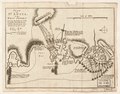
English: Scale ca. 1:51,000. Relief shown by hachures. Oriented with north to the left. Shows attacks made on Dec. 13-Dec. 16. Includes descriptive text. LC Maps of North America, 1750-1789, 2073 Available also through the Library of Congress Web site as a raster image. Vault AACR2: 651/1; 651/2 |
||
| Title | Plan of St. Lucia, in the West Indies: Shewing the positions of the English and French forces with the attacks made at its reduction in Decr. 1778. | ||
| Shelf ID | G5111.S2 1778 .B6 | ||
| Date | |||
| Source | https://www.loc.gov/item/74696150/ | ||
| Author | Bowen, Thomas | ||
| Permission (Reusing this file) |
|
||
| Other versions |
|
||
| Location | Saint Lucia. · Saint Lucia | ||
| Part of | Military Battles And Campaigns · American Memory · Catalog · Geography And Map Division · American Revolution And Its Era: Maps And Charts Of North America And The West Indies, 1750-1789 | ||
| Subject | Saint Lucia, Battle Of, Saint Lucia · Maps · Early Works To 1800 · Saint Lucia · History |


Licensing
|
This is a faithful photographic reproduction of a two-dimensional, public domain work of art. The work of art itself is in the public domain for the following reason:
The official position taken by the Wikimedia Foundation is that "faithful reproductions of two-dimensional public domain works of art are public domain".
This photographic reproduction is therefore also considered to be in the public domain in the United States. In other jurisdictions, re-use of this content may be restricted; see Reuse of PD-Art photographs for details. | ||||
File history
Click on a date/time to view the file as it appeared at that time.
| Date/Time | Thumbnail | Dimensions | User | Comment | |
|---|---|---|---|---|---|
| current | 20:47, 7 January 2023 | | 3,107 × 2,324 (3.17 MB) | PawełMM | Cropped 3 % horizontally, 7 % vertically using CropTool with lossless mode. The tatty edges removed. |
| 07:23, 6 January 2023 |  | 3,190 × 2,495 (3.31 MB) | PawełMM | cleaned, border removed | |
| 00:55, 16 December 2018 |  | 3,296 × 2,584 (1.3 MB) | Fæ | LOC Maps https://www.loc.gov/item/74696150/ #9214 |
File usage
The following pages on the English Wikipedia use this file (pages on other projects are not listed):
Global file usage
The following other wikis use this file:
- Usage on he.wikipedia.org
- Usage on zh.wikipedia.org