
File:Plym Bridge - geograph.org.uk - 121307.jpg
No higher resolution available.
Plym_Bridge_-_geograph.org.uk_-_121307.jpg (640 × 427 pixels, file size: 125 KB, MIME type: image/jpeg)
| This is a file from the Wikimedia Commons. Information from its description page there is shown below. Commons is a freely licensed media file repository. You can help. |
Summary
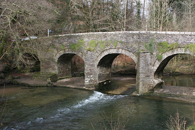
This is a photo of listed building number 1386329. |
| Description |
English: Plym Bridge. This old bridge over the river Plym is an access point to the recreational area of the Plym valley woodlands. The bridge used to be the lowest crossing on the river. It is now closed to motor vehicles to avoid this route being used as a rat run. Car parks at either side of the bridge give access to visitors. |
| Date | |
| Source | From geograph.org.uk |
| Author | Tony Atkin |
| Attribution (required by the license) | Tony Atkin / Plym Bridge / |
| Object location | | View this and other nearby images on: OpenStreetMap |
|---|
_&language=en)
Licensing

|
This image was taken from the Geograph project collection. See this photograph's page on the Geograph website for the photographer's contact details. The copyright on this image is owned by Tony Atkin and is licensed for reuse under the Creative Commons Attribution-ShareAlike 2.0 license.
|
This file is licensed under the Creative Commons Attribution-Share Alike 2.0 Generic license.
Attribution: Tony Atkin
- You are free:
- to share – to copy, distribute and transmit the work
- to remix – to adapt the work
- Under the following conditions:
- attribution – You must give appropriate credit, provide a link to the license, and indicate if changes were made. You may do so in any reasonable manner, but not in any way that suggests the licensor endorses you or your use.
- share alike – If you remix, transform, or build upon the material, you must distribute your contributions under the same or compatible license as the original.
File history
Click on a date/time to view the file as it appeared at that time.
| Date/Time | Thumbnail | Dimensions | User | Comment | |
|---|---|---|---|---|---|
| current | 04:16, 31 January 2010 | | 640 × 427 (125 KB) | GeographBot | == {{int:filedesc}} == {{Information |description={{en|1=Plym Bridge. This old bridge over the river Plym is an access point to the recreational area of the Plym valley woodlands. The bridge used to be the lowest crossing on the river. It is now closed |
File usage
The following pages on the English Wikipedia use this file (pages on other projects are not listed):
Global file usage
The following other wikis use this file:
- Usage on www.wikidata.org