
File:Rajputana States - Census of India 1891.jpg

Size of this preview: 386 × 599 pixels. Other resolutions: 154 × 240 pixels | 309 × 480 pixels | 495 × 768 pixels | 660 × 1,024 pixels | 1,450 × 2,250 pixels.
Original file (1,450 × 2,250 pixels, file size: 189 KB, MIME type: image/jpeg)
| This is a file from the Wikimedia Commons. Information from its description page there is shown below. Commons is a freely licensed media file repository. You can help. |
Summary
| Description |
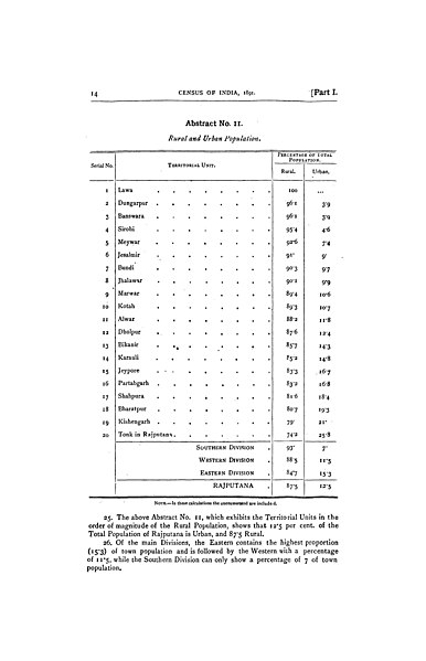
English: Image shows the page listing of 20 princely states of Rajputana in 1891. The 1891 Census of India was conducted by the British Raj and covered the lands now part of India, Pakistan, Bangladesh and Burma. The Census Commissioner was Jervoise Athelstane Baines, who was later knighted for his work in India. |
| Date | |
| Source | https://archive.org/details/dli.granth.112411/page/14/mode/2up?view=theater |
| Author |
The 1891 Census of India was conducted by the British Raj and covered the lands now part of India, Pakistan, Bangladesh and Burma. The Census Commissioner was Jervoise Athelstane Baines, who was later knighted for his work in India. Above picture shows the page which contains the population distribution of 20 territorial units of Rajputana Agency of British times. Lawa State was the smallest independent state. |
Licensing
This file is licensed under the Creative Commons Attribution-Share Alike 4.0 International license.
- You are free:
- to share – to copy, distribute and transmit the work
- to remix – to adapt the work
- Under the following conditions:
- attribution – You must give appropriate credit, provide a link to the license, and indicate if changes were made. You may do so in any reasonable manner, but not in any way that suggests the licensor endorses you or your use.
- share alike – If you remix, transform, or build upon the material, you must distribute your contributions under the same or compatible license as the original.
File history
Click on a date/time to view the file as it appeared at that time.
| Date/Time | Thumbnail | Dimensions | User | Comment | |
|---|---|---|---|---|---|
| current | 20:43, 18 October 2022 | | 1,450 × 2,250 (189 KB) | Tpsn98290 | Uploaded a work by The 1891 Census of India was conducted by the British Raj and covered the lands now part of India, Pakistan, Bangladesh and Burma. The Census Commissioner was Jervoise Athelstane Baines, who was later knighted for his work in India. Above picture shows the page which contains the population distribution of 20 territorial units of Rajputana Agency of British times. Lawa State was the smallest independent state. from https://archive.org/details/dli.granth.112411/page/14/mode... |
File usage
The following pages on the English Wikipedia use this file (pages on other projects are not listed):
Global file usage
The following other wikis use this file:
- Usage on ur.wikipedia.org