
File:Roadkill on Route 170 Okatie Hwy by the Chechessee River, SC, USA, jjron 09.04.2012.jpg

Original file (3,384 × 2,220 pixels, file size: 2.32 MB, MIME type: image/jpeg)
| This is a file from the Wikimedia Commons. Information from its description page there is shown below. Commons is a freely licensed media file repository. You can help. |
| This is a featured picture, which means that members of the community have identified it as one of the finest images on the English Wikipedia, adding significantly to its accompanying article. If you have a different image of similar quality, be sure to upload it using the proper free license tag, add it to a relevant article, and nominate it. |
| This image was selected as picture of the day on the English Wikipedia for April 14, 2014. |
Summary
|
| Description |
العربية: أيلٌ قُتل جرَّاء حادث اصطدام مع سيَّارة على طريق أوكاتاي السريع (الطريق رقم 170 السريع) على ضفاف نهر چيچيزي، في ولاية كارولينا الجنوبيَّة، بالولايات المُتحدة. ما يُحيطُ بالأيل هو عبارة عن مزيجٍ من أشلاءه وحُطامُ السيَّارة التي تكسَّر جزءٌ منها عندما صدمته. تظهرُ آثارُ دولابٍ فوق ظهر الحيوان، مما يعني أنَّهُ دُهس دهسًا.
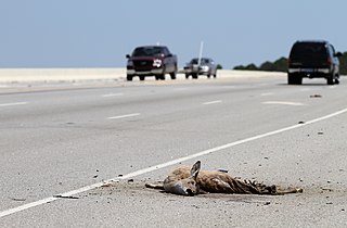
English: Roadkilled deer on the Okatie Highway (Highway 170) alongside the Chechesee River, South Carolina, USA. The debris surrounding the deer is a mixture of the dismembered animal and parts broken off the car that has hit it. A tire track appears to pass over the back portion of the animal. |
|||
| Date | ||||
| Source | Own work | |||
| Author | jjron | |||
| Permission (Reusing this file) |
|
|||
| Other versions |
.jpg)
| Camera location | | View this and other nearby images on: OpenStreetMap |
|---|
Licensing

|
Permission is granted to copy, distribute and/or modify this document under the terms of the GNU Free Documentation License, Version 1.2 only as published by the Free Software Foundation; with no Invariant Sections, no Front-Cover Texts, and no Back-Cover Texts. A copy of the license is included in the section entitled GNU Free Documentation License. | 1.2 only |
| Annotations | This image is annotated: View the annotations at Commons |
File history
Click on a date/time to view the file as it appeared at that time.
| Date/Time | Thumbnail | Dimensions | User | Comment | |
|---|---|---|---|---|---|
| current | 13:43, 24 June 2012 | | 3,384 × 2,220 (2.32 MB) | Jjron | {{Information |Description= {{en|Roadkilled deer on the Okatie Highway (Route 170) alongside the Chechesee River, South Carolina, USA.}} |Source={{Own}} |Author=jjron |Date=2012-04-09 |Permission={{jjron}} |other_version... |
File usage
- Deer–vehicle collisions
- Roadkill
- Transportation safety in the United States
- Talk:Roadkill/Archive 1
- User:Jjron
- User:Jjron/Gallery/Animals
- User:Jjron/Gallery/FPs
- User:Jjron/Gallery/Places/USA
- User:Jjron/Gallery/Transportation
- User talk:Elekhh/Archive 2013
- User talk:Elekhh/Archive 2014
- User talk:Jjron/Archive 8
- User talk:Jjron/Archive 9
- Wikipedia:Featured picture candidates/January-2013
- Wikipedia:Featured picture candidates/Roadkill
- Wikipedia:Featured pictures/Vehicles/Land
- Wikipedia:Featured pictures thumbs/33
- Wikipedia:Main Page history/2014 April 14
- Wikipedia:Picture of the day/April 2014
- Template:POTD/2014-04-14
Global file usage
The following other wikis use this file:
- Usage on ar.wikipedia.org
- قتل على الطرقات
- ويكيبيديا:صور مختارة/حيوانات/ثدييات
- ويكيبيديا:ترشيحات الصور المختارة/حادثة على الطريق
- بوابة:محتوى متميز/14 يونيو 2015
- ويكيبيديا:صورة اليوم المختارة/يناير 2016
- قالب:صورة اليوم المختارة/2016-01-04
- ويكيبيديا:صورة اليوم المختارة/فبراير 2019
- قالب:صورة اليوم المختارة/2019-02-10
- ويكيبيديا:صورة اليوم المختارة/مارس 2022
- قالب:صورة اليوم المختارة/2022-03-02
- Usage on de.wikipedia.org
- Usage on el.wikipedia.org
- Usage on es.wikipedia.org
- Usage on he.wikipedia.org
- Usage on it.wikipedia.org
- Usage on ja.wikipedia.org
- Usage on km.wikipedia.org
- Usage on ko.wikipedia.org
- Usage on pl.wikipedia.org
- Usage on pt.wikipedia.org
- Usage on www.wikidata.org
- Usage on zh.wikipedia.org