
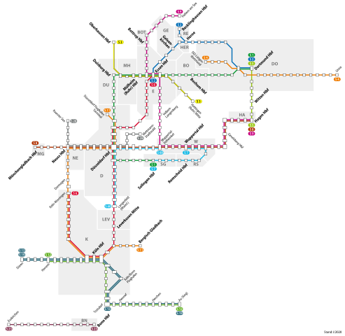
File:S-Bahn Rhein-Ruhr 2020.svg

Original file (SVG file, nominally 1,490 × 1,450 pixels, file size: 298 KB)
| This is a file from the Wikimedia Commons. Information from its description page there is shown below. Commons is a freely licensed media file repository. You can help. |
Summary
| Description | |
| Date | |
| Source | Own work |
| Author | NordNordWest |

|
This map has been made or improved in the German Kartenwerkstatt (Map Lab). You can propose maps to improve as well.
|
Licensing
Usage of this file with:

explanatory notes: Legally binding is only the full legalcode. For a free usage I recommend to respect the following licence conditions:
1. Provide my name as given above: NordNordWest,
2. a copy of, or the URI for, the applicable license: https://creativecommons.org/licenses/by-sa/3.0/de/legalcode,
3. the title of the work,
4. in the case of an adaptation, a credit identifying the use of the work in the adaptation.
This license and the rights granted hereunder will terminate automatically upon any breach by you of the terms of this license. Any of the above conditions can be waived if you get permission from the copyright holder. If you have questions or wish differing conditions, please contact me through nnwest or my discussion page ![]() t-online.de
t-online.de
- You are free:
- to share – to copy, distribute and transmit the work
- to remix – to adapt the work
- Under the following conditions:
- attribution – You must give appropriate credit, provide a link to the license, and indicate if changes were made. You may do so in any reasonable manner, but not in any way that suggests the licensor endorses you or your use.
- share alike – If you remix, transform, or build upon the material, you must distribute your contributions under the same or compatible license as the original.

File history
Click on a date/time to view the file as it appeared at that time.
| Date/Time | Thumbnail | Dimensions | User | Comment | |
|---|---|---|---|---|---|
| current | 15:39, 15 May 2020 | | 1,490 × 1,450 (298 KB) | NordNordWest | corr |
| 19:04, 13 May 2020 |  | 1,490 × 1,450 (298 KB) | NordNordWest | Gladbeck–Recklinghausen didn't start in May | |
| 15:54, 13 May 2020 |  | 1,490 × 1,450 (328 KB) | Metrophil | Corrected some lines (S9 to Hagen, Recklinghausen; S6 to Köln-Worringen), added some more text | |
| 21:07, 11 May 2020 |  | 1,490 × 1,450 (265 KB) | NordNordWest | == {{int:filedesc}} == {{Information |Description= {{de|1=Netzplan der S-Bahn Rhein-Ruhr und S-Bahn Köln 2016}} |Source={{Own}} |Date=2016-01-02 |Author={{U|NordNordWest}} |Permission= |other_versions= }} {{Kartenwerkstatt}} == {{int:license-header}} == {{User:NordNordWest/LicenceMap}} Category:Maps of S-Bahn Rhein-Ruhr Category:Maps of S-Bahn Köln Category:Public transport maps of North Rhine-Westphalia [[Category:SVG transport maps... |
File usage
Global file usage
The following other wikis use this file:
- Usage on de.wikipedia.org
- Usage on es.wikipedia.org
- Usage on fa.wikipedia.org
- Usage on fr.wikipedia.org
- Usage on hu.wikipedia.org
- Usage on it.wikipedia.org
- Usage on ja.wikipedia.org
- Usage on ko.wikipedia.org
- Usage on lmo.wikipedia.org
- Usage on pl.wikipedia.org
- Usage on ru.wikipedia.org
- Usage on uk.wikipedia.org
- Usage on www.wikidata.org
- Usage on zh.wikipedia.org