
File:SFRYugoslaviaNumbered.svg

Size of this PNG preview of this SVG file: 595 × 431 pixels. Other resolutions: 320 × 232 pixels | 640 × 464 pixels | 1,024 × 742 pixels | 1,280 × 927 pixels | 2,560 × 1,854 pixels.
Original file (SVG file, nominally 595 × 431 pixels, file size: 125 KB)
| This is a file from the Wikimedia Commons. Information from its description page there is shown below. Commons is a freely licensed media file repository. You can help. |
| Description |
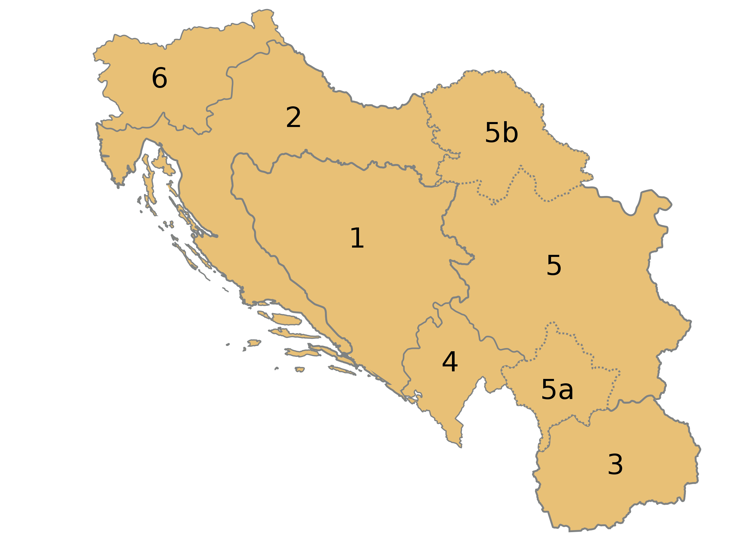
English: Numbered map of the Socialist Federal Republic of Yugoslavia. # Socialist republic of Bosnia and Herzegovina, with capital in Sarajevo, # Socialist republic of Croatia, with capital in Zagreb, # Socialist republic of Macedonia, with capital in Skopje, # Socialist republic of Montenegro, with capital in Titograd, # Socialist republic of Serbia, with capital in Belgrade, which also contained:
5a. Socialist autonomous province of Kosovo, with capital in Priština 5b. Socialist autonomous province of Vojvodina, with capital in Novi Sad # Socialist republic of Slovenia, with capital in Ljubljana. Español: República Socialista Federal de Yugoslavia, con sus territorios numerados:
1.-Bosnia-Hercegovina 2.-Croacia 3.-Macedonia 4.-Montenegro 5.-Serbia 5a.-Kosovo 5b.-Voivodina 6.-Eslovenia |
| Date | (UTC) |
| Source | |
| Author |
|
| This is a retouched picture, which means that it has been digitally altered from its original version. Modifications: Turned into SVG and colours slightly changed. The original can be viewed here: SFRYugoslaviaNumbered.png: File:SFRYugoslaviaNumbered.png. Modifications made by Rowanwindwhistler.
|
This file is licensed under the Creative Commons Attribution-Share Alike 3.0 Unported license.
- You are free:
- to share – to copy, distribute and transmit the work
- to remix – to adapt the work
- Under the following conditions:
- attribution – You must give appropriate credit, provide a link to the license, and indicate if changes were made. You may do so in any reasonable manner, but not in any way that suggests the licensor endorses you or your use.
- share alike – If you remix, transform, or build upon the material, you must distribute your contributions under the same or compatible license as the original.
Original upload log
This image is a derivative work of the following images:
- File:SFRYugoslaviaNumbered.png licensed with Cc-by-sa-3.0-migrated-with-disclaimers, GFDL-en
- 2008-10-26T15:40:20Z Milosevo 941x824 (28657 Bytes) transparent background
- 2007-06-07T17:01:26Z Aivazovsky 941x824 (28311 Bytes)
- 2007-06-07T13:52:03Z Aivazovsky 941x824 (28314 Bytes) Fixing Macedonian border
- 2005-09-17T06:42:05Z Muu-karhu 928x824 (12498 Bytes)
Uploaded with derivativeFX
File history
Click on a date/time to view the file as it appeared at that time.
| Date/Time | Thumbnail | Dimensions | User | Comment | |
|---|---|---|---|---|---|
| current | 13:00, 3 September 2010 | | 595 × 431 (125 KB) | Rowanwindwhistler | {{Information |Description={{en|1=Numbered map of the Socialist Federal Republic of Yugoslavia. # Socialist republic of Bosnia and Herzegovina, with capital in Sarajevo, # Socialist republic of [[ |
File usage
The following pages on the English Wikipedia use this file (pages on other projects are not listed):
Global file usage
The following other wikis use this file:
- Usage on ast.wikipedia.org
- Usage on es.wikipedia.org
- Usage on eu.wikipedia.org
- Usage on gl.wikipedia.org
- Usage on ru.wikipedia.org
- Usage on sh.wikipedia.org