
File:SMOS2010.png

Size of this preview: 800 × 337 pixels. Other resolutions: 320 × 135 pixels | 640 × 270 pixels | 1,418 × 598 pixels.
Original file (1,418 × 598 pixels, file size: 1,009 KB, MIME type: image/png)
| This is a file from the Wikimedia Commons. Information from its description page there is shown below. Commons is a freely licensed media file repository. You can help. |
Summary
| Description |
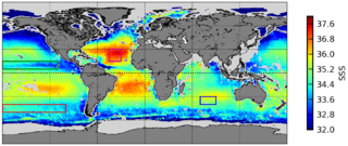
English: A map of surface salinity levels (between 32 and 38‰) recorded between August & September of 2010 and 2011 by the European Space Agency's Soil Moisture and Ocean Salinity (SMOS) satellite, the first such satellite in the world. [Cropped from source to remove non-released image.] |
| Date | |
| Source | "Sea Surface Salinity.jpg" at the European Space Agency's Space in Images |
| Author | SMOS GLOSCAL Cal/Val project |
Licensing

|
The copyright holder of this file allows anyone to use it for any purpose, provided that the copyright holder is properly attributed. Redistribution, derivative work, commercial use, and all other use is permitted. |
|
|
Released 1 October 2012 at 12:14 pm.
Although commercial use is permitted, the ESA requests layout and copy be submitted to spaceinimages@esa.int to verify that the use of the image does not falsely state or imply ESA endorsement of a product, process, or service (i.e., violate fraud statutes).
File history
Click on a date/time to view the file as it appeared at that time.
| Date/Time | Thumbnail | Dimensions | User | Comment | |
|---|---|---|---|---|---|
| current | 05:39, 6 August 2014 | | 1,418 × 598 (1,009 KB) | LlywelynII | User created page with UploadWizard |
File usage
The following pages on the English Wikipedia use this file (pages on other projects are not listed):
Global file usage
The following other wikis use this file:
- Usage on ar.wikipedia.org
- Usage on fa.wikipedia.org
- Usage on gl.wikipedia.org
- Usage on pt.wikipedia.org
- Usage on sr.wikipedia.org
- Usage on www.wikidata.org
- Usage on zh.wikipedia.org