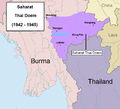
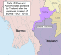
File:Saharat Thai Doem map 1942-1945.png

Size of this preview: 663 × 600 pixels. Other resolutions: 265 × 240 pixels | 531 × 480 pixels | 962 × 870 pixels.
Original file (962 × 870 pixels, file size: 165 KB, MIME type: image/png)
Summary[edit]
| Description |
English: Parts of Shan and Kayah states annexed by Thailand after the Japanese invasion of Burma |
|---|---|
| Source |
Own work |
| Date |
2014-09-21 17:51:40 |
| Author | |
| Permission (Reusing this file) |
See below.
|
Licensing[edit]
I, the copyright holder of this work, hereby publish it under the following license:
| This work is licensed under the Creative Commons Attribution-ShareAlike 4.0 License. |
| This media file is either in the public domain or published under a free license, and contains no inbound file links. If this media file is useful, then it should be transferred to the Wikimedia Commons. If this media is not useful, then please propose it for deletion or list it at files for discussion. |
File history
Click on a date/time to view the file as it appeared at that time.
| Date/Time | Thumbnail | Dimensions | User | Comment | |
|---|---|---|---|---|---|
| current | 18:21, 22 October 2014 |  | 962 × 870 (165 KB) | Murashel (talk | contribs) | |
| 08:55, 19 October 2014 |  | 962 × 870 (167 KB) | Xufanc (talk | contribs) | replaced unsourced version with historical version | |
| 10:20, 21 September 2014 |  | 962 × 870 (165 KB) | Murashel (talk | contribs) | ||
| 10:16, 21 September 2014 |  | 962 × 870 (166 KB) | Murashel (talk | contribs) | Parts of Shan and Kayah states annexed by Thailand after the Japanese invasion of Burma. |
You cannot overwrite this file.
File usage
No pages on the English Wikipedia use this file (pages on other projects are not listed).
