
File:Satellite Lanzarote Chinijo.jpg
No higher resolution available.
Satellite_Lanzarote_Chinijo.jpg (422 × 253 pixels, file size: 30 KB, MIME type: image/jpeg)
| This is a file from the Wikimedia Commons. Information from its description page there is shown below. Commons is a freely licensed media file repository. You can help. |
Summary
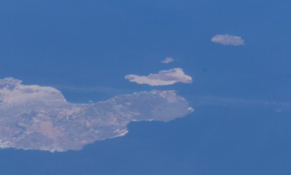
Español: De abajo a arriba, Lanzarote, La Graciosa, Montaña Clara y Alegranza
Satellite photo showing Lanzarote and Chinijo Archipielago. From bottom to top, Lanzarote, La Graciosa, Montaña Clara y Alegranza.
| This file is in the public domain in the United States because it was solely created by NASA. NASA copyright policy states that "NASA material is not protected by copyright unless noted". (See Template:PD-USGov, NASA copyright policy page or JPL Image Use Policy.) | ||
 |
Warnings:
|
Source
Image courtesy of the Image Analysis Laboratory, NASA Johnson Space Center.
File history
Click on a date/time to view the file as it appeared at that time.
| Date/Time | Thumbnail | Dimensions | User | Comment | |
|---|---|---|---|---|---|
| current | 07:05, 25 June 2005 | | 422 × 253 (30 KB) | Porao | Imagen de satélite de Lanzarote y el Archipiélago Chinijo. De abajo a arriba, Lanzarote, La Graciosa, Montaña Clara y Alegranza. |
File usage
The following pages on the English Wikipedia use this file (pages on other projects are not listed):
Global file usage
The following other wikis use this file:
- Usage on az.wikipedia.org
- Usage on de.wikipedia.org
- Usage on eo.wikipedia.org
- Usage on es.wikipedia.org
- Usage on fa.wikipedia.org
- Usage on fr.wikipedia.org
- Usage on gl.wikipedia.org
- Usage on id.wikipedia.org
- Usage on it.wikipedia.org
- Usage on nl.wikipedia.org
- Usage on nn.wikipedia.org
- Usage on no.wikipedia.org
- Usage on pl.wikipedia.org
- Usage on pt.wikipedia.org
- Usage on ru.wikipedia.org
- Usage on sk.wikipedia.org
- Usage on sv.wikipedia.org
- Usage on uk.wikipedia.org
- Usage on zh.wikipedia.org