
File:Satsunan Islands.png

Size of this preview: 432 × 600 pixels. Other resolutions: 173 × 240 pixels | 346 × 480 pixels | 780 × 1,083 pixels.
Original file (780 × 1,083 pixels, file size: 76 KB, MIME type: image/png)
| This is a file from the Wikimedia Commons. Information from its description page there is shown below. Commons is a freely licensed media file repository. You can help. |

|
This locator map image could be re-created using vector graphics as an SVG file. This has several advantages; see Commons:Media for cleanup for more information. If an SVG form of this image is available, please upload it and afterwards replace this template with
{{vector version available|new image name}}.
It is recommended to name the SVG file “Satsunan Islands.svg”—then the template Vector version available (or Vva) does not need the new image name parameter. |
Summary
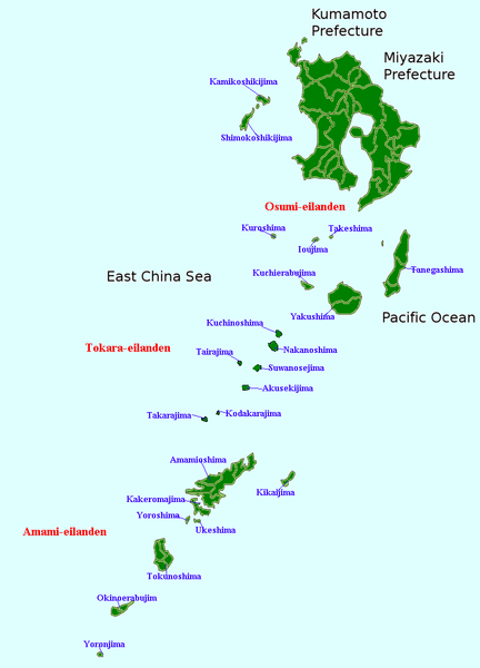
| Description | Map of the Satsunan Islands (Ōsumi Islands + Tokara Islands + Amami Islands), Ryukyu , Japan |
| Date | (UTC) |
| Source | Own work |
| Author | Krisgrotius |
| Other versions |
Derivative works of this file: |
Licensing
| I, the copyright holder of this work, release this work into the public domain. This applies worldwide. In some countries this may not be legally possible; if so: I grant anyone the right to use this work for any purpose, without any conditions, unless such conditions are required by law. |
File history
Click on a date/time to view the file as it appeared at that time.
| Date/Time | Thumbnail | Dimensions | User | Comment | |
|---|---|---|---|---|---|
| current | 16:16, 5 January 2007 | | 780 × 1,083 (76 KB) | Krisgrotius | {{Information |Description=Map of the Satsunan Islands (Ōsumi Islands + Tokara Islands + Amami Islands), Ryukyu , Japan |Source= own work |Date=~~~~~ |Author=~~~ |Permission= |other_versions= public }} |
File usage
No pages on the English Wikipedia use this file (pages on other projects are not listed).
Global file usage
The following other wikis use this file:
- Usage on cy.wikipedia.org
- Usage on fa.wikipedia.org
- Usage on nl.wikipedia.org