
File:Scotland Map British Isles.PNG

Size of this preview: 800 × 534 pixels. Other resolutions: 320 × 214 pixels | 640 × 427 pixels | 968 × 646 pixels.
Original file (968 × 646 pixels, file size: 78 KB, MIME type: image/png)
| This is a file from the Wikimedia Commons. Information from its description page there is shown below. Commons is a freely licensed media file repository. You can help. |
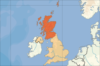
| Description | Location of Scotland in the British Isles. | |||
| Date | ||||
| Source | Self-made. Based upon an original work forming part of the "Europe location" map series created by David Liuzzo: Image:Europe_location_SCO.png | |||
| Author | Rab-k | |||
| Permission (Reusing this file) |
|
|||
| Other versions |
|


File history
Click on a date/time to view the file as it appeared at that time.
| Date/Time | Thumbnail | Dimensions | User | Comment | |
|---|---|---|---|---|---|
| current | 17:12, 6 April 2008 | | 968 × 646 (78 KB) | Rab-k | {{Information |Description= Location of Scotland in the British Isles. |Source=Self-made. Based upon an original work forming part of the "Europe location" map series created by David Liuzzo: [[:Image:Europe_location_SCO.png |
File usage
The following pages on the English Wikipedia use this file (pages on other projects are not listed):