
File:Serre Road Cemetery No. 2 - Somme, France - 2117-1.jpg

Original file (5,472 × 3,648 pixels, file size: 5.83 MB, MIME type: image/jpeg)
| This is a file from the Wikimedia Commons. Information from its description page there is shown below. Commons is a freely licensed media file repository. You can help. |
Summary
| Description |
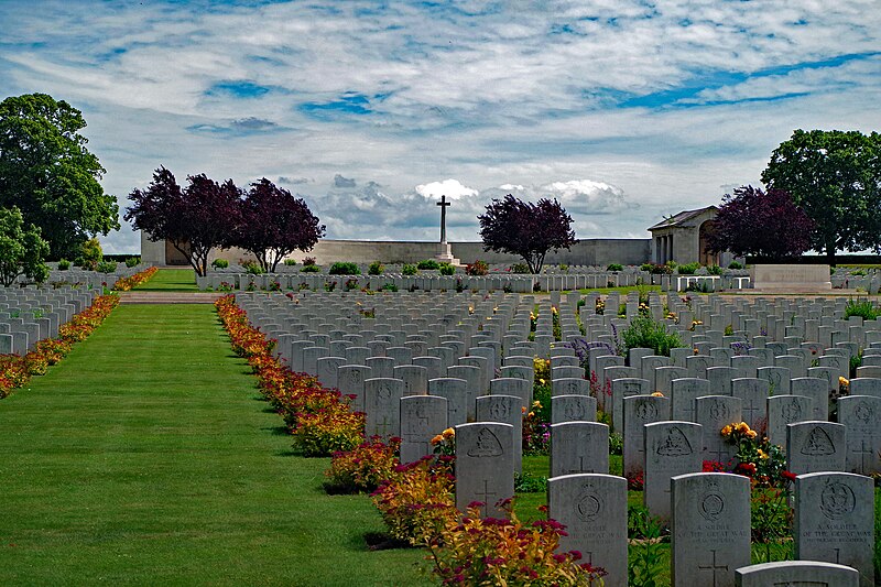
English: Serre Road Cemetary No. 2 - Serre-lès-Puisieux (Puisieux), Somme, France |
| Date | |
| Source | Own work |
| Author | Gary Dee |
| Camera location | | View this and other nearby images on: OpenStreetMap |
|---|
Location Information
The village of Serre is 11 kilometres north-north-east of Albert.
Using the D919 from Arras to Amiens you will drive through the villages of Bucquoy, Puisieux then Serre-les-Puisieux (approximately 20 kilometres south of Arras). On leaving Serre-les-Puisieux, 1.3 kilometres further along the D919, Serre Road No.2 Cemetery can be found on the left hand side.
Historical Information
In June 1916, the road out of Mailly-Maillet to Serre and Puisieux entered No Man's Land about 1,300 metres south-west of Serre. On 1 July 1916, the 31st and 4th Divisions attacked north and south of this road and although parties of the 31st Division reached Serre, the attack failed. The 3rd and 31st Divisions attacked once more on the 13 November, but again without success.
Early in 1917, the Germans fell back to the Hindenburg Line and on 25 February, Serre was occupied by the 22nd Manchesters. The village changed hands once more in March 1918 and remained under German occupation, until they withdrew in August.
In the spring of 1917, the battlefields of the Somme and Ancre were cleared by V Corps and a number of new cemeteries were made, three of which are now named from the Serre Road. Serre Road Cemetery No.2 was begun in May 1917 and by the end of the war it contained approximately 475 graves (Plots I and II, except for Row E, Plot II which was added in 1922 and Row AA, Plot I which was added in 1927), but it was greatly enlarged after the Armistice by the addition of further graves from the surrounding area, including graves from the following smaller cemeteries:-
BAIZIEUX COMMUNAL CEMETERY (Somme): one United Kingdom grave March 1918. BOISMONT CHURCHYARD (Somme): one United Kingdom grave of October 1914. BUCQUOY COMMUNAL CEMETERY (Pas-de-Calais): 25 United Kingdom graves of August 1918. ERCHEU CHURCHYARD (Somme): one United Kingdom grave of March 1918. FRETTECUISSE CHURCHYARD (Somme): one United Kingdom grave September 1916. HERVILLY CHURCHYARD (Somme): one R.F.C. grave of September 1916. HOLNON COMMUNAL CEMETERY (Aisne): five United Kingdom graves April 1917. LABOISSIERE CHURCHYARD (Somme): one United Kingdom grave of April 1917. LE SARS GERMAN CEMETERY (Pas-de-Calais): one United Kingdom grave. MADAME MILITARY CEMETERY, CLERY-SUR-SOMME (Somme): three United Kingdom graves of February 1917. MEAULTE CHURCHYARD (Somme): one United Kingdom grave of April 1916. POZIERES COMMUNAL CEMETERY (Somme): one Canadian grave of September 1916. REMIENCOURT COMMUNAL CEMETERY (Somme): one United Kingdom grave of April 1918. SOMME AMERICAN CEMETERY, BONY (Aisne): two United Kingdom graves of July and October 1918, and one Australian of September 1918. VOYENNES CHURCHYARD (Somme): seven United Kingdom graves of March 1918. YTRES CHURCHYARD (Pas-de-Calais): 14 United Kingdom and four New Zealand graves of September 1918, mainly from the 15th Field Ambulance.
There are now 7,127 Commonwealth burials of the First World War in the cemetery, mostly dating from 1916. Of these, 4,944 are unidentified.
The cemetery, which was not completed until 1934, was designed by Sir Edwin Lutyens.
http://www.cwgc.org/find-a-cemetery/cemetery/67200/SERRE%20ROAD%20CEMETERY%20NO.2
Licensing
- You are free:
- to share – to copy, distribute and transmit the work
- to remix – to adapt the work
- Under the following conditions:
- attribution – You must give appropriate credit, provide a link to the license, and indicate if changes were made. You may do so in any reasonable manner, but not in any way that suggests the licensor endorses you or your use.
- share alike – If you remix, transform, or build upon the material, you must distribute your contributions under the same or compatible license as the original.
File history
Click on a date/time to view the file as it appeared at that time.
| Date/Time | Thumbnail | Dimensions | User | Comment | |
|---|---|---|---|---|---|
| current | 10:58, 3 June 2016 | | 5,472 × 3,648 (5.83 MB) | Gary Dee | User created page with UploadWizard |
File usage
Global file usage
The following other wikis use this file:
- Usage on de.wikipedia.org