
File:Siege of Kobane.svg

Size of this PNG preview of this SVG file: 800 × 531 pixels. Other resolutions: 320 × 213 pixels | 640 × 425 pixels | 1,024 × 680 pixels | 1,280 × 850 pixels | 2,560 × 1,701 pixels | 1,850 × 1,229 pixels.
Original file (SVG file, nominally 1,850 × 1,229 pixels, file size: 466 KB)
| This is a file from the Wikimedia Commons. Information from its description page there is shown below. Commons is a freely licensed media file repository. You can help. |
Summary
| Description | |
| Date | |
| Source |
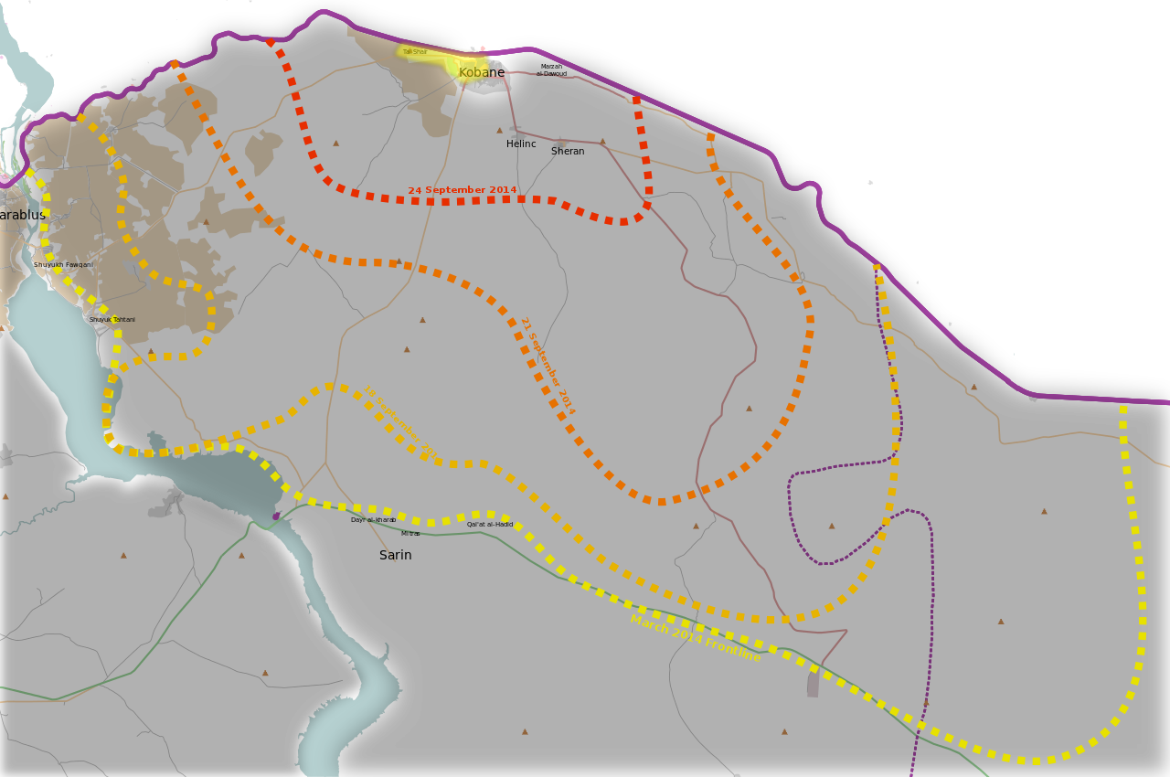
Map originally made by Mouradi. |
| Author | Mouradi |
| SVG development |
Licensing
I, the copyright holder of this work, hereby publish it under the following license:
This file is licensed under the Creative Commons Attribution-Share Alike 3.0 Unported license.
- You are free:
- to share – to copy, distribute and transmit the work
- to remix – to adapt the work
- Under the following conditions:
- attribution – You must give appropriate credit, provide a link to the license, and indicate if changes were made. You may do so in any reasonable manner, but not in any way that suggests the licensor endorses you or your use.
- share alike – If you remix, transform, or build upon the material, you must distribute your contributions under the same or compatible license as the original.
File history
Click on a date/time to view the file as it appeared at that time.
| Date/Time | Thumbnail | Dimensions | User | Comment | |
|---|---|---|---|---|---|
| current | 12:49, 30 October 2014 | | 1,850 × 1,229 (466 KB) | Mouradi | YPG controls Tall Shaer. http://www.dailymail.co.uk/news/article-2793880/the-great-kobane-fightback-symbolic-recapture-hill-black-flag-isis-kurdish-fighters-swathes-city-step-airstrikes.html |
| 15:15, 11 October 2014 |  | 1,850 × 1,229 (465 KB) | MrPenguin20 | Update according to http://www.thetimes.co.uk/tto/multimedia/archive/00781/inline_b7a952ca-4da_781457a.jpg | |
| 00:22, 5 October 2014 |  | 1,850 × 1,229 (465 KB) | MrPenguin20 | Added changes showing current level of control (as of 5th October 2014). Evolution of siege done from information from BBC (http://news.bbcimg.co.uk/media/images/77873000/jpg/_77873560_kobane_map624-2.jpg), ArchiCivilians (https://twitter.com/archicivi... | |
| 22:36, 26 March 2014 |  | 1,850 × 1,229 (465 KB) | Mouradi | User created page with UploadWizard |
File usage
The following pages on the English Wikipedia use this file (pages on other projects are not listed):
Global file usage
The following other wikis use this file:
- Usage on ar.wikipedia.org
- Usage on az.wikipedia.org
- Usage on be.wikipedia.org
- Usage on ckb.wikipedia.org
- Usage on de.wikipedia.org
- Usage on es.wikipedia.org
- Usage on fr.wikipedia.org
- Usage on he.wikipedia.org
- Usage on hu.wikipedia.org
- Usage on it.wikipedia.org
- Usage on ja.wikipedia.org
- Usage on nl.wikipedia.org
- Usage on pl.wikipedia.org
- Usage on ro.wikipedia.org
- Usage on ru.wikipedia.org
- Usage on tr.wikipedia.org
- Usage on zh.wikipedia.org