
File:Snow depth chart noaa nsm depth 2014010705 National.jpg

Size of this preview: 800 × 457 pixels. Other resolutions: 320 × 183 pixels | 801 × 458 pixels.
Original file (801 × 458 pixels, file size: 80 KB, MIME type: image/jpeg)
| This is a file from the Wikimedia Commons. Information from its description page there is shown below. Commons is a freely licensed media file repository. You can help. |
Summary
| Description |
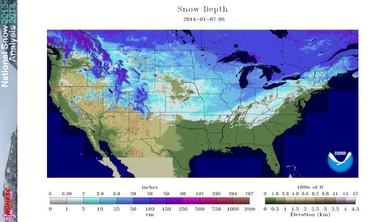
English: National Weather Service map showing snow depth for the US and part of Canada for January 7, 2014. |
| Date | |
| Source | Snow depth chart downloaded for the date indicated: http://www.nohrsc.noaa.gov/nsa/ |
| Author | NOAA, National Operational Hydrologic Remote Sensing Center |
Licensing
This image is in the public domain because it contains materials that originally came from the U.S. National Oceanic and Atmospheric Administration, taken or made as part of an employee's official duties.
|
File history
Click on a date/time to view the file as it appeared at that time.
| Date/Time | Thumbnail | Dimensions | User | Comment | |
|---|---|---|---|---|---|
| current | 14:45, 7 January 2014 | | 801 × 458 (80 KB) | Oaktree b | User created page with UploadWizard |
File usage
The following pages on the English Wikipedia use this file (pages on other projects are not listed):
Global file usage
The following other wikis use this file:
- Usage on nl.wikipedia.org