
File:South Alpine lakes.png
Size of this preview: 800 × 494 pixels. Other resolutions: 320 × 197 pixels | 640 × 395 pixels | 1,240 × 765 pixels.
Original file (1,240 × 765 pixels, file size: 599 KB, MIME type: image/png)
| This is a file from the Wikimedia Commons. Information from its description page there is shown below. Commons is a freely licensed media file repository. You can help. |
Summary
| Description |
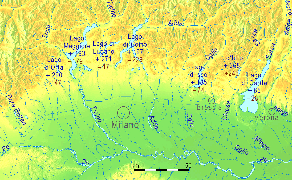
English: Fjord-like lakes on the southern side of the Alps, blue figures = water level in meters above sea level, brown figures = maximum depth of lake in meters above (" + ") or below (" - ") sea level
Deutsch: Seen des südlichen Alpenrandes, blaue Zahlen = Höhe des Seespiegels über dem Meer, braune Zahlen = maximale Tiefe des Sees über (" + ") oder unter (" - ") dem Meeresspiegel.
Italiano: Laghi prealpini a sud delle Alpi. Cifre in blu = altitudine dello specchio d'acqua; cifre in marrone = altitudine del punto più profondo sopra (" + ") oppure sotto (" - ") il livello del mare.
Español: Lagos en la parte meridional de los Alpes en Italia. Números en azul = altitud de la superficie. Números en marrón = altitud de los puntos más profundos sobre (" + ") o bajo (" - ") del nivel del mar. |
| Source | http://www.maps-for-free.com |
| Author | Ulamm 14:19, 18 March 2008 (UTC) |
Licensing
This file is licensed under the Creative Commons Attribution-Share Alike 3.0 Unported license.
- You are free:
- to share – to copy, distribute and transmit the work
- to remix – to adapt the work
- Under the following conditions:
- attribution – You must give appropriate credit, provide a link to the license, and indicate if changes were made. You may do so in any reasonable manner, but not in any way that suggests the licensor endorses you or your use.
- share alike – If you remix, transform, or build upon the material, you must distribute your contributions under the same or compatible license as the original.
File history
Click on a date/time to view the file as it appeared at that time.
| Date/Time | Thumbnail | Dimensions | User | Comment | |
|---|---|---|---|---|---|
| current | 18:52, 14 October 2013 | | 1,240 × 765 (599 KB) | Ulamm | Depth of Lago Maggiore corrected |
| 15:18, 18 March 2008 |  | 1,240 × 765 (599 KB) | Ulamm | ||
| 15:09, 18 March 2008 |  | 1,240 × 765 (599 KB) | Ulamm | ||
| 14:59, 18 March 2008 |  | 1,240 × 765 (599 KB) | Ulamm | ||
| 14:55, 18 March 2008 |  | 1,240 × 765 (599 KB) | Ulamm | ||
| 14:22, 18 March 2008 |  | 1,240 × 765 (599 KB) | Ulamm | {{Information |Description={{en|Fjordlike lakes on the southern side of the Alps,<br>blue figures = water level in meters above sea level,<br>brown figures = deepest site of the ground in meters above (" + ") or below (" - ") sea level}}{{de|Seen des süd | |
| 14:19, 18 March 2008 |  | 827 × 510 (731 KB) | Ulamm | {{Information |Description={{en|Fjordlike lakes on the southern side of the Alps,<br>blue figures = water level in meters above sea level,<br>brown figures = deepest site of the ground in meters above (" + ") or below (" - ") sea level}}{{de|Seen des süd |
File usage
The following pages on the English Wikipedia use this file (pages on other projects are not listed):
Global file usage
The following other wikis use this file:
- Usage on de.wikipedia.org
- Usage on es.wikipedia.org
- Usage on it.wikipedia.org
- Usage on mk.wikipedia.org
- Usage on sl.wikipedia.org