
File:Stadtbezirke Lage in München.png
No higher resolution available.
Stadtbezirke_Lage_in_München.png (500 × 378 pixels, file size: 38 KB, MIME type: image/png)
| This is a file from the Wikimedia Commons. Information from its description page there is shown below. Commons is a freely licensed media file repository. You can help. |

|
This locator map image could be re-created using vector graphics as an SVG file. This has several advantages; see Commons:Media for cleanup for more information. If an SVG form of this image is available, please upload it and afterwards replace this template with
{{vector version available|new image name}}.
It is recommended to name the SVG file “Stadtbezirke Lage in München.svg”—then the template Vector version available (or Vva) does not need the new image name parameter. |
Summary
| Description |
|
| Date | |
| Source | originally uploaded to de.wikipedia by author, self-made by author |
| Author | Tom Gensler |
| Permission (Reusing this file) |
GNU-FDL |
- List of references and voucher please send to chef@tomg.de
Licensing

|
Permission is granted to copy, distribute and/or modify this document under the terms of the GNU Free Documentation License, Version 1.2 or any later version published by the Free Software Foundation; with no Invariant Sections, no Front-Cover Texts, and no Back-Cover Texts. A copy of the license is included in the section entitled GNU Free Documentation License. |
| This file is licensed under the Creative Commons Attribution-Share Alike 3.0 Unported license. | ||
| ||
| This licensing tag was added to this file as part of the GFDL licensing update. |
File history
Click on a date/time to view the file as it appeared at that time.
| Date/Time | Thumbnail | Dimensions | User | Comment | |
|---|---|---|---|---|---|
| current | 21:39, 20 August 2007 | | 500 × 378 (38 KB) | Chumwa | Fehlende Bezirksgrenze auf Anregung von User:Rdb ergänzt. |
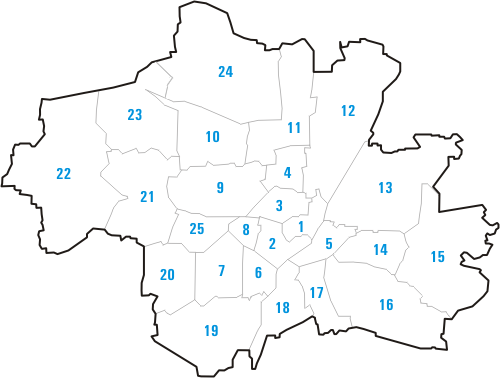
| 13:42, 31 October 2005 |  | 500 × 378 (37 KB) | Schaengel89~commonswiki | {{Information| |Description = # Altstadt-Lehel # Ludwigsvorstadt-Isarvorstadt # Maxvorstadt # Schwabing-West # Au-Haidhausen # Sendling # Sendling-Westpark # Schwanthalerhöhe # Neuhausen-Nymphenburg # Moosach # Milbertshofen-Am Hart # Schwabing-Freimann |
File usage
The following pages on the English Wikipedia use this file (pages on other projects are not listed):
Global file usage
The following other wikis use this file:
- Usage on an.wikipedia.org
- Usage on ay.wikipedia.org
- Usage on azb.wikipedia.org
- Usage on da.wikipedia.org
- Usage on de.wikipedia.org
- Usage on fi.wikipedia.org
- Usage on ie.wikipedia.org
- Usage on ja.wikipedia.org
- Usage on ko.wikipedia.org
- Usage on lb.wikipedia.org
- Usage on pl.wikipedia.org
- Usage on pt.wikipedia.org
- Usage on qu.wikipedia.org
- Usage on scn.wikipedia.org
- Usage on sl.wikipedia.org
- Usage on ta.wikipedia.org
- Usage on zh.wikipedia.org