
File:Stadtplan Stalino LOC 2012593213.jpg

Size of this preview: 800 × 536 pixels. Other resolutions: 320 × 214 pixels | 640 × 429 pixels | 1,024 × 686 pixels | 1,280 × 858 pixels | 2,560 × 1,716 pixels | 19,556 × 13,107 pixels.
Original file (19,556 × 13,107 pixels, file size: 25.28 MB, MIME type: image/jpeg)
| This is a file from the Wikimedia Commons. Information from its description page there is shown below. Commons is a freely licensed media file repository. You can help. |
Summary
| Warning | The original file is very high-resolution. It might not load properly or could cause your browser to freeze when opened at full size. |
|---|
| Description |
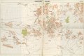
English: "Stand: 1. 1943." Also shows numbered administrative wards (Bezirke). Unidentified grid. Former security restriction in upper margin: Nicht für die Öffentlichkeit bestimmt! Printed in western/eastern segments. Available also through the Library of Congress Web site as a raster image. Includes note. LC copy imperfect: Use-worn, fold-lined, rubber-stamped. |
||
| Title | Stadtplan Stalino | ||
| Shelf ID | G7104.D6 1943 .G4 | ||
| Date | |||
| Source | https://www.loc.gov/item/2012593213/ | ||
| Author | Germany. Heer. D. 415 | ||
| Permission (Reusing this file) |
|
||
| Other versions |
|
||
| Location | Ukraine · Donet︠S︡K. · Donet︠S︡K · Donet︠S︡K Metropolitan Area | ||
| Part of | American Memory · Cities And Towns · Catalog · Geography And Map Division | ||
| Subject | Ukraine · Military Maps · Donet︠S︡K (Ukraine) · Donet︠S︡K · Donet︠S︡K Metropolitan Area (Ukraine) · Maps · Donet︠S︡K Metropolitan Area |

Licensing
This work is in the public domain in the United States because it is a work prepared by an officer or employee of the United States Government as part of that person’s official duties under the terms of Title 17, Chapter 1, Section 105 of the US Code.
Note: This only applies to original works of the Federal Government and not to the work of any individual U.S. state, territory, commonwealth, county, municipality, or any other subdivision. This template also does not apply to postage stamp designs published by the United States Postal Service since 1978. (See § 313.6(C)(1) of Compendium of U.S. Copyright Office Practices). It also does not apply to certain US coins; see The US Mint Terms of Use.
|
 | |
| This file has been identified as being free of known restrictions under copyright law, including all related and neighboring rights. | ||
File history
Click on a date/time to view the file as it appeared at that time.
| Date/Time | Thumbnail | Dimensions | User | Comment | |
|---|---|---|---|---|---|
| current | 13:16, 15 May 2018 | | 19,556 × 13,107 (25.28 MB) | Fæ | LOC Maps https://www.loc.gov/item/2012593213/ #544 |
File usage
The following pages on the English Wikipedia use this file (pages on other projects are not listed):
Global file usage
The following other wikis use this file: