
File:Stanley Valley.jpg

Size of this preview: 800 × 262 pixels. Other resolutions: 320 × 105 pixels | 640 × 210 pixels | 1,024 × 335 pixels | 1,280 × 419 pixels | 2,560 × 838 pixels | 12,290 × 4,025 pixels.
Original file (12,290 × 4,025 pixels, file size: 20.57 MB, MIME type: image/jpeg)
| This is a file from the Wikimedia Commons. Information from its description page there is shown below. Commons is a freely licensed media file repository. You can help. |
| This is a featured picture, which means that members of the community have identified it as one of the finest images on the English Wikipedia, adding significantly to its accompanying article. If you have a different image of similar quality, be sure to upload it using the proper free license tag, add it to a relevant article, and nominate it. |
Summary
| Description |
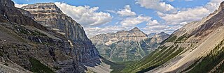
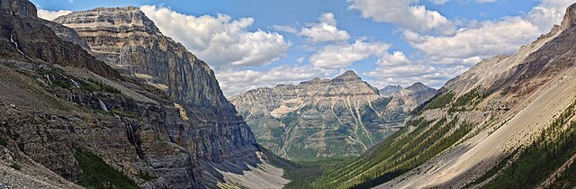
English: Stanley Valley and Mount Whymper viewed from the Stanley Glacier Trail.
|
||
| Date | Taken on 5 July 2023 | ||
| Source |
Own work This image was created with Hugin. This image was created with darktable. |
||
| Author | The Cosmonaut | ||
| Permission (Reusing this file) |
This file is licensed under the Creative Commons Attribution-Share Alike 2.5 Canada license.
 |
| Camera location | | View this and other nearby images on: OpenStreetMap |
|---|
|
File history
Click on a date/time to view the file as it appeared at that time.
| Date/Time | Thumbnail | Dimensions | User | Comment | |
|---|---|---|---|---|---|
| current | 19:08, 19 January 2024 | 12,290 × 4,025 (20.57 MB) | The Cosmonaut | Reprocessed | |
| 02:25, 5 August 2023 | 18,485 × 6,055 (44.65 MB) | The Cosmonaut | == {{int:filedesc}} == {{Information |description={{en|1=Stanley Valley.}}{{Protected areas in Canada|Q903323}} |date= {{taken on|2023-07-05|location=Canada}} |source={{own}}<br> {{hugin}}<br> {{Created with darktable}} |Author= The Cosmonaut |permission={{Cc-by-sa-2.5-ca}} |other versions= }} {{Location dec|51.18253|-116.04401|}} Category:Mount Whymper |
File usage
The following pages on the English Wikipedia use this file (pages on other projects are not listed):