
File:Stoughton Barracks, Guildford - geograph.org.uk - 58144.jpg
No higher resolution available.
Stoughton_Barracks,_Guildford_-_geograph.org.uk_-_58144.jpg (640 × 427 pixels, file size: 97 KB, MIME type: image/jpeg)
| This is a file from the Wikimedia Commons. Information from its description page there is shown below. Commons is a freely licensed media file repository. You can help. |
Summary
| Description |
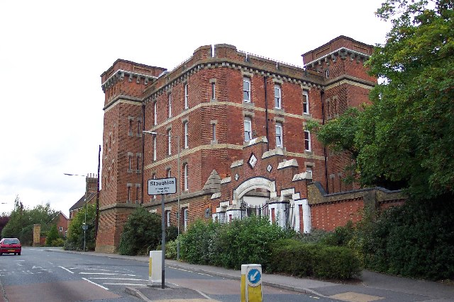
English: Stoughton Barracks, Guildford. This is the keep of Stoughton Barracks, built in 1876 as part of the army reforms carried out by Edward Cardwell, Gladstone's Secretary of State for War between 1870 and 1874, hence its nickname of Cardwell's Keep. Cardwell decided that each army regiment should be associated with a locality and Guildford was chosen as the headquarters of the 2nd Regiment of Foot The Queens, one of the founding regiments of the British Army. In 1881 it became the Queens Royal West Surrey Regiment. In 1959, when it amalgamated with the East Surreys to become the Queens Royal Surrey Regiment, it left Stoughton. The Barracks then became a Regional Control Centre until the MOD moved out in 1983. It then remained derelict until being converted to residential use in 2000. |
| Date | |
| Source | From geograph.org.uk |
| Author | Ron Strutt |
| Attribution (required by the license) | Ron Strutt / Stoughton Barracks, Guildford / |
| Camera location | | View this and other nearby images on: OpenStreetMap |
|---|
_heading:315.00&language=en)
| Object location | | View this and other nearby images on: OpenStreetMap |
|---|
_heading:315.00&language=en)
Licensing

|
This image was taken from the Geograph project collection. See this photograph's page on the Geograph website for the photographer's contact details. The copyright on this image is owned by Ron Strutt and is licensed for reuse under the Creative Commons Attribution-ShareAlike 2.0 license.
|
This file is licensed under the Creative Commons Attribution-Share Alike 2.0 Generic license.
Attribution: Ron Strutt
- You are free:
- to share – to copy, distribute and transmit the work
- to remix – to adapt the work
- Under the following conditions:
- attribution – You must give appropriate credit, provide a link to the license, and indicate if changes were made. You may do so in any reasonable manner, but not in any way that suggests the licensor endorses you or your use.
- share alike – If you remix, transform, or build upon the material, you must distribute your contributions under the same or compatible license as the original.
File history
Click on a date/time to view the file as it appeared at that time.
| Date/Time | Thumbnail | Dimensions | User | Comment | |
|---|---|---|---|---|---|
| current | 19:33, 30 January 2010 | | 640 × 427 (97 KB) | GeographBot | == {{int:filedesc}} == {{Information |description={{en|1=Stoughton Barracks, Guildford. This is the keep of Stoughton Barracks, built in 1876 as part of the army reforms carried out by Edward Cardwell, Gladstone's Secretary of State for War between 1870 a |
File usage
The following pages on the English Wikipedia use this file (pages on other projects are not listed):