
File:Swinscoe Hill - geograph.org.uk - 224670.jpg
No higher resolution available.
Swinscoe_Hill_-_geograph.org.uk_-_224670.jpg (640 × 519 pixels, file size: 52 KB, MIME type: image/jpeg)
| This is a file from the Wikimedia Commons. Information from its description page there is shown below. Commons is a freely licensed media file repository. You can help. |
Summary
| Description |
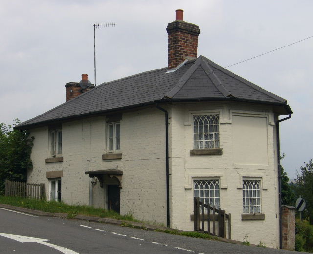
English: Swinscoe Hill. At the junction with Birdsgrove Lane, Mayfield, Staffordshire. This may be a toll cottage because this is the Ashbourne - Leek - Congleton Turnpike. However this very detailed page http://freepages.genealogy.rootsweb.com/~acwager/html/TollRoadsAndEnglishLandscape.htm states that tollkeepers cottages "were in general small and cheaply made". So possibly this is a gatehouse to Okeover Park. |
| Date | |
| Source | From geograph.org.uk |
| Author | Roger W Haworth |
| Attribution (required by the license) | Roger W Haworth / Swinscoe Hill / |
| Object location | | View this and other nearby images on: OpenStreetMap |
|---|
_heading:45.00&language=en)
Licensing

|
This image was taken from the Geograph project collection. See this photograph's page on the Geograph website for the photographer's contact details. The copyright on this image is owned by Roger W Haworth and is licensed for reuse under the Creative Commons Attribution-ShareAlike 2.0 license.
|
This file is licensed under the Creative Commons Attribution-Share Alike 2.0 Generic license.
Attribution: Roger W Haworth
- You are free:
- to share – to copy, distribute and transmit the work
- to remix – to adapt the work
- Under the following conditions:
- attribution – You must give appropriate credit, provide a link to the license, and indicate if changes were made. You may do so in any reasonable manner, but not in any way that suggests the licensor endorses you or your use.
- share alike – If you remix, transform, or build upon the material, you must distribute your contributions under the same or compatible license as the original.
File history
Click on a date/time to view the file as it appeared at that time.
| Date/Time | Thumbnail | Dimensions | User | Comment | |
|---|---|---|---|---|---|
| current | 01:07, 1 February 2010 | | 640 × 519 (52 KB) | GeographBot | == {{int:filedesc}} == {{Information |description={{en|1=Swinscoe Hill. At the junction with Birdsgrove Lane, Mayfield, Staffordshire. This may be a toll cottage because this is the Ashbourne - Leek - Congleton Turnpike. However this very detailed page ht |
File usage
The following pages on the English Wikipedia use this file (pages on other projects are not listed):