
File:TCWR Map.png

Original file (1,082 × 872 pixels, file size: 57 KB, MIME type: image/png)
Summary[edit]
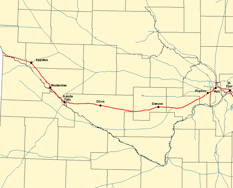
Map of the Twin Cities and Western Railroad. Solid lines are TCWR track; dotted lines are track over which TCWR has trackage rights.
Created with Quantum GIS using data from the MNDOT Railroad basemap. The disclaimer on their site says: The Minnesota Department of Transportation makes no representation or warranties, express or implied, with respect to the reuse of data provided herewith, regardless of its format or the means of its transmission. There is no guarantee or representation to the user as to the accuracy, currency, suitability, or reliability of this data for any purpose. The user accepts the data 'as is', and assumes all risks associated with its use. By accepting this data, the user agrees not to transmit this data or provide access to it or any part of it to another party unless the user shall include with the data a copy of this disclaimer. The Minnesota Department of Transportation assumes no responsibility for actual or consequential damage incurred as a result of any user's reliance on this data.
Licensing[edit]
 | Permission is granted to copy, distribute and/or modify this document under the terms of the GNU Free Documentation License, Version 1.2 or any later version published by the Free Software Foundation; with no Invariant Sections, no Front-Cover Texts, and no Back-Cover Texts. Subject to disclaimers. |
| This work is licensed under the Creative Commons Attribution-ShareAlike 3.0 License. This licensing tag was added to this file as part of the GFDL licensing update. |
| This file is licensed under the Creative Commons Attribution-ShareAlike license versions 2.5, 2.0, and 1.0. |
 | This file is a candidate to be copied to Wikimedia Commons.
Any user may perform this transfer; refer to Wikipedia:Moving files to Commons for details. If this file has problems with attribution, copyright, or is otherwise ineligible for Commons, then remove this tag and DO NOT transfer it; repeat violators may be blocked from editing. Other Instructions
| ||
| |||
File history
Click on a date/time to view the file as it appeared at that time.
| Date/Time | Thumbnail | Dimensions | User | Comment | |
|---|---|---|---|---|---|
| current | 21:25, 2 September 2006 | | 1,082 × 872 (57 KB) | Elkman (talk | contribs) | Map of the Twin Cities and Western Railroad. Solid lines are TCWR track; dotted lines are track over which TCWR has trackage rights. Created with Quantum GIS using data from the [http://www.dot.state.mn.us/tda/basemap/metadata/Railroad.htm MNDOT |
You cannot overwrite this file.