
File:Teahitia seamount map.jpg

Size of this preview: 602 × 599 pixels. Other resolutions: 241 × 240 pixels | 482 × 480 pixels | 771 × 768 pixels | 1,028 × 1,024 pixels | 2,304 × 2,294 pixels.
Original file (2,304 × 2,294 pixels, file size: 1.04 MB, MIME type: image/jpeg)
| This is a file from the Wikimedia Commons. Information from its description page there is shown below. Commons is a freely licensed media file repository. You can help. |
Summary
| Description |
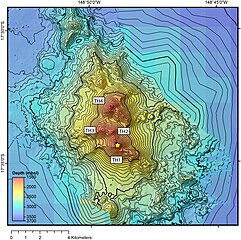
English: Multibeam bathymetric plot of Teahitia Seamount as mapped during RV Thomas G. Thompson cruise TGT303 in December 2013. TH1-TH4 represent the four principle cones of this composite volcano. Yellow star shows the location of US GEOTRACES CTD Station GP16-37 occupied directly above the TH1 cone at 17 • 34.4 S, 148 • 49.0 W using the ship's dynamic positioning system. |
| Date | |
| Source | https://www.researchgate.net/figure/Multibeam-bathymetric-plot-of-Teahitia-Seamount-as-mapped-during-RV-Thomas-G-Thompson_fig3_339411737 |
| Author | Christopher R. German, Joseph A. Resing, Guangyu Xu, Isobel A. Yeo, Sharon L. Walker, Colin W. Devey, James W. Moffett, Gregory A. Cutter, Olivier Hyvernaud and Dominique Reymond |
Licensing
This file is licensed under the Creative Commons Attribution 4.0 International license.
- You are free:
- to share – to copy, distribute and transmit the work
- to remix – to adapt the work
- Under the following conditions:
- attribution – You must give appropriate credit, provide a link to the license, and indicate if changes were made. You may do so in any reasonable manner, but not in any way that suggests the licensor endorses you or your use.
File history
Click on a date/time to view the file as it appeared at that time.
| Date/Time | Thumbnail | Dimensions | User | Comment | |
|---|---|---|---|---|---|
| current | 04:41, 18 December 2022 | | 2,304 × 2,294 (1.04 MB) | IdiotSavant | Uploaded a work by Christopher R. German, Joseph A. Resing, Guangyu Xu, Isobel A. Yeo, Sharon L. Walker, Colin W. Devey, James W. Moffett, Gregory A. Cutter, Olivier Hyvernaud and Dominique Reymond from https://www.researchgate.net/figure/Multibeam-bathymetric-plot-of-Teahitia-Seamount-as-mapped-during-RV-Thomas-G-Thompson_fig3_339411737 with UploadWizard |
File usage
The following pages on the English Wikipedia use this file (pages on other projects are not listed):