
File:Tectonic map of southwest Japan.png

Size of this preview: 800 × 534 pixels. Other resolutions: 320 × 213 pixels | 640 × 427 pixels | 877 × 585 pixels.
Original file (877 × 585 pixels, file size: 251 KB, MIME type: image/png)
| This is a file from the Wikimedia Commons. Information from its description page there is shown below. Commons is a freely licensed media file repository. You can help. |
Summary
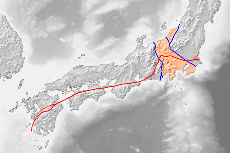
九州地方~関東地方の地質構造図。Image:Topographic30deg N30E120.pngをもとに、[1] archive copy at the Wayback Machine, [2]を参考に作成。
線や色分けの意味は次のとおり。
- 赤線:ja:中央構造線
- 左の青線:ja:糸魚川静岡構造線
- 右の青線:ja:柏崎千葉構造線、新発田小出構造線
- 薄い赤色:ja:フォッサマグナ地域
赤・青の太い線は現在主力の説、細い線は主力ではない説。
Licensing

|
Permission is granted to copy, distribute and/or modify this document under the terms of the GNU Free Documentation License, Version 1.2 or any later version published by the Free Software Foundation; with no Invariant Sections, no Front-Cover Texts, and no Back-Cover Texts. A copy of the license is included in the section entitled GNU Free Documentation License. |
| This file is licensed under the Creative Commons Attribution-Share Alike 3.0 Unported license. | ||
| ||
| This licensing tag was added to this file as part of the GFDL licensing update. |
File history
Click on a date/time to view the file as it appeared at that time.
| Date/Time | Thumbnail | Dimensions | User | Comment | |
|---|---|---|---|---|---|
| current | 13:17, 6 January 2017 | | 877 × 585 (251 KB) | Æskja | w:ja:ノート:中央構造線で説明します。Reverted to version as of 14:45, 5 January 2017 (UTC) |
| 05:39, 6 January 2017 |  | 877 × 585 (198 KB) | Hyper neo | Wrong Information | |
| 14:45, 5 January 2017 |  | 877 × 585 (251 KB) | Æskja | Reverted to version as of 11:47, 18 June 2011 (UTC) | |
| 15:15, 5 September 2016 |  | 877 × 585 (198 KB) | Hyper neo | renew (remove wrong lines in Kyushu island) | |
| 11:47, 18 June 2011 |  | 877 × 585 (251 KB) | Qrsk075 | renew | |
| 02:53, 9 August 2006 |  | 877 × 585 (215 KB) | Pekachu | 九州地方~関東地方の地質構造図。Image:Topographic30deg N30E120.pngをもとに、[http://www.osk.janis.or.jp/~mtl-muse/subindex03.htm], [http://www3.cnet.ne.jp/pas31225og/FosMagna.htm]を参考に作成。 線や色分けの意味は� |
File usage
The following pages on the English Wikipedia use this file (pages on other projects are not listed):
Global file usage
The following other wikis use this file:
- Usage on ast.wikipedia.org
- Usage on de.wikipedia.org
- Usage on es.wikipedia.org
- Usage on fr.wikipedia.org
- Usage on it.wikipedia.org
- Usage on ja.wikipedia.org
- Usage on ja.wikibooks.org
- Usage on ko.wikipedia.org
- Usage on ru.wikipedia.org
- Usage on sl.wikipedia.org
- Usage on uk.wikipedia.org
- Usage on www.wikidata.org
- Usage on zh.wikipedia.org