
File:Tell Abyad region post-offensive.png
No higher resolution available.
Tell_Abyad_region_post-offensive.png (679 × 464 pixels, file size: 66 KB, MIME type: image/png)
| This is a file from the Wikimedia Commons. Information from its description page there is shown below. Commons is a freely licensed media file repository. You can help. |
Summary
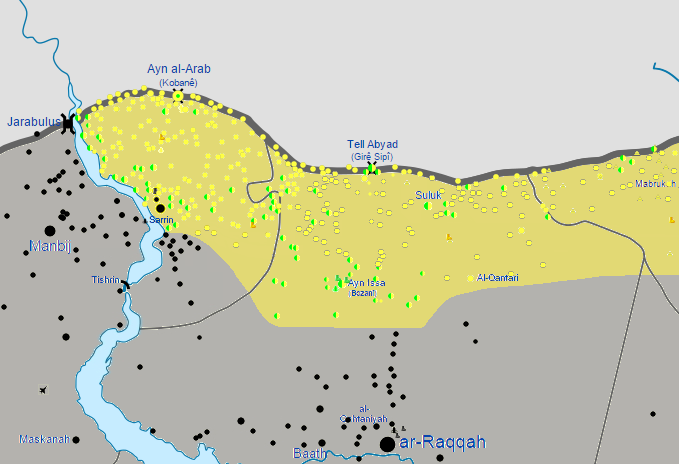
| Description |
English: Map of the Kobanî Canton, Tell Abyad countryside, and the western Al-Hasakah Governorate, after the end of the Kurdish-launched Tell Abyad offensive (2015), on July 10, 2015.
English: Controlled by the Syrian Government Government
Controlled by Syrian Kurdistan
Controlled by the Syrian opposition
Controlled by the Islamic State of Iraq and the Levant |
| Date | |
| Source | Own work |
| Author | BlueHypercane761 |
Licensing
I, the copyright holder of this work, hereby publish it under the following license:
This file is licensed under the Creative Commons Attribution-Share Alike 4.0 International license.
- You are free:
- to share – to copy, distribute and transmit the work
- to remix – to adapt the work
- Under the following conditions:
- attribution – You must give appropriate credit, provide a link to the license, and indicate if changes were made. You may do so in any reasonable manner, but not in any way that suggests the licensor endorses you or your use.
- share alike – If you remix, transform, or build upon the material, you must distribute your contributions under the same or compatible license as the original.
File history
Click on a date/time to view the file as it appeared at that time.
| Date/Time | Thumbnail | Dimensions | User | Comment | |
|---|---|---|---|---|---|
| current | 08:21, 1 August 2015 | | 679 × 464 (66 KB) | BlueHypercane761 | User created page with UploadWizard |
File usage
The following pages on the English Wikipedia use this file (pages on other projects are not listed):
Global file usage
The following other wikis use this file:
- Usage on ca.wikipedia.org
- Usage on es.wikipedia.org
- Usage on fr.wikipedia.org
- Usage on pt.wikipedia.org