
File:The Church of St Leonard, Kirkstead - geograph.org.uk - 556138.jpg
No higher resolution available.
The_Church_of_St_Leonard,_Kirkstead_-_geograph.org.uk_-_556138.jpg (640 × 480 pixels, file size: 75 KB, MIME type: image/jpeg)
| This is a file from the Wikimedia Commons. Information from its description page there is shown below. Commons is a freely licensed media file repository. You can help. |
Summary
| Description |
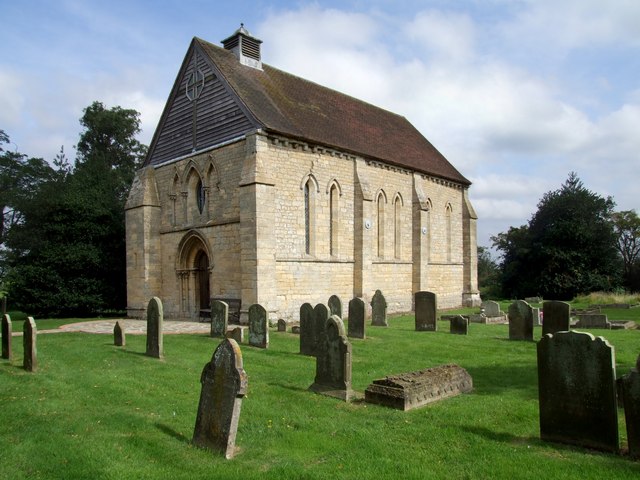
English: The Church of St Leonard, Kirkstead The church stands just inside the boundary of the ruins of Kirkstead Abbey. The tiny chapel, measuring 42ft x 19ft, may well have been built as a chantry chapel in memory of Robert de Tattershall who died in 1212. St Leonards is as built in the first years of the 13th century, except for the roof. At the intersection of the ceiling ribs are splendid bosses carved with foliage and the Lamb of God. Part of the chancel screen is probably the same date as the building and the earliest in existence. The narrow west door and the newel stair are original. In the chancel is part of a mutilated piscina and an aumbry in the north wall. |
| Date | |
| Source | From geograph.org.uk |
| Author | Dave Hitchborne |
| Attribution (required by the license) | Dave Hitchborne / The Church of St Leonard, Kirkstead / |
| Camera location | | View this and other nearby images on: OpenStreetMap |
|---|
_heading:0.00&language=en)
| Object location | | View this and other nearby images on: OpenStreetMap |
|---|
_heading:0.00&language=en)
Licensing

|
This image was taken from the Geograph project collection. See this photograph's page on the Geograph website for the photographer's contact details. The copyright on this image is owned by Dave Hitchborne and is licensed for reuse under the Creative Commons Attribution-ShareAlike 2.0 license.
|
This file is licensed under the Creative Commons Attribution-Share Alike 2.0 Generic license.
Attribution: Dave Hitchborne
- You are free:
- to share – to copy, distribute and transmit the work
- to remix – to adapt the work
- Under the following conditions:
- attribution – You must give appropriate credit, provide a link to the license, and indicate if changes were made. You may do so in any reasonable manner, but not in any way that suggests the licensor endorses you or your use.
- share alike – If you remix, transform, or build upon the material, you must distribute your contributions under the same or compatible license as the original.
File history
Click on a date/time to view the file as it appeared at that time.
| Date/Time | Thumbnail | Dimensions | User | Comment | |
|---|---|---|---|---|---|
| current | 04:21, 6 February 2011 | | 640 × 480 (75 KB) | GeographBot | == {{int:filedesc}} == {{Information |description={{en|1=The Church of St Leonard, Kirkstead The church stands just inside the boundary of the ruins of Kirkstead Abbey. The tiny chapel, measuring 42ft x 19ft, may well have been built as a chantry chapel i |
File usage
The following pages on the English Wikipedia use this file (pages on other projects are not listed):
Global file usage
The following other wikis use this file:
- Usage on arz.wikipedia.org
- Usage on www.wikidata.org