
File:Twizel Viaduct - geograph.org.uk - 1205605.jpg
No higher resolution available.
Twizel_Viaduct_-_geograph.org.uk_-_1205605.jpg (640 × 427 pixels, file size: 132 KB, MIME type: image/jpeg)
| This is a file from the Wikimedia Commons. Information from its description page there is shown below. Commons is a freely licensed media file repository. You can help. |
Summary
| Description |
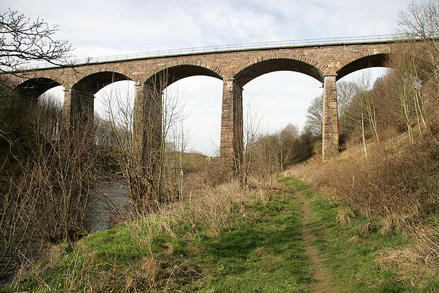
English: Twizel Viaduct This impressive structure spanning the River Till carried the Tweedmouth to Kelso railway line that was closed in the early 1960s. Built in 1849, it was recently upgraded to allow public access over the bridge thereby linking in with a network of public footpaths. The 6-arch viaduct, also known as St Cuthberts Viaduct, is a grade 2 listed structure under the care of BRB (Residuary) Ltd who are responsible for the remaining assets of the British Railways Board. The 5 arches shown here are just within the square. Viewed from the public footpath to Twizel Boathouse |
| Date | |
| Source | From geograph.org.uk |
| Author | Walter Baxter |
| Attribution (required by the license) | Walter Baxter / Twizel Viaduct / |
| Camera location | | View this and other nearby images on: OpenStreetMap |
|---|
_heading:247.00&language=en)
| Object location | | View this and other nearby images on: OpenStreetMap |
|---|
_heading:247.00&language=en)
Licensing

|
This image was taken from the Geograph project collection. See this photograph's page on the Geograph website for the photographer's contact details. The copyright on this image is owned by Walter Baxter and is licensed for reuse under the Creative Commons Attribution-ShareAlike 2.0 license.
|
This file is licensed under the Creative Commons Attribution-Share Alike 2.0 Generic license.
Attribution: Walter Baxter
- You are free:
- to share – to copy, distribute and transmit the work
- to remix – to adapt the work
- Under the following conditions:
- attribution – You must give appropriate credit, provide a link to the license, and indicate if changes were made. You may do so in any reasonable manner, but not in any way that suggests the licensor endorses you or your use.
- share alike – If you remix, transform, or build upon the material, you must distribute your contributions under the same or compatible license as the original.
File history
Click on a date/time to view the file as it appeared at that time.
| Date/Time | Thumbnail | Dimensions | User | Comment | |
|---|---|---|---|---|---|
| current | 04:55, 26 February 2011 | | 640 × 427 (132 KB) | GeographBot | == {{int:filedesc}} == {{Information |description={{en|1=Twizel Viaduct This impressive structure spanning the River Till carried the Tweedmouth to Kelso railway line that was closed in the early 1960s. Built in 1849, it was recently upgraded to allow pub |
File usage
The following pages on the English Wikipedia use this file (pages on other projects are not listed):
Global file usage
The following other wikis use this file:
- Usage on www.wikidata.org