
File:U1034 Tensta kyrka - KMB - 16001000254384.jpg
Size of this preview: 399 × 599 pixels. Other resolutions: 160 × 240 pixels | 524 × 787 pixels.
Original file (524 × 787 pixels, file size: 150 KB, MIME type: image/jpeg)
| This is a file from the Wikimedia Commons. Information from its description page there is shown below. Commons is a freely licensed media file repository. You can help. |
| Camera location | | View this and other nearby images on: OpenStreetMap |
|---|
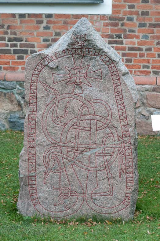
| U1034 Tensta kyrka
( |
|||||||||||||||||||||||||||
|---|---|---|---|---|---|---|---|---|---|---|---|---|---|---|---|---|---|---|---|---|---|---|---|---|---|---|---|
| Photographer |
|
||||||||||||||||||||||||||
| Title |
U1034 Tensta kyrka |
||||||||||||||||||||||||||
| Original caption |
Notera Av dokumentationsskäl har originalbeskrivningen från Riksantikvarieämbetet behållits. Tillrättalägganden och alternativa beskrivningar bör införas separat från nedanstående information. RAÄ-nummer Tensta 90:1. Inskriften lyder: "Torbjörn och Torsten och Styrbjörn läto resa stenen efter Torfast, sin fader. Öpir ristade". Runstenen står rest på kyrkogården några meter söder om kyrkan.Felaktigheter kan även anmälas till denna sida. Motiv: U1034 Tensta kyrka |
||||||||||||||||||||||||||
| Description |
RAÄ-nummer Tensta 90:1. Inskriften lyder: "Torbjörn och Torsten och Styrbjörn läto resa stenen efter Torfast, sin fader. Öpir ristade". Runstenen står rest på kyrkogården några meter söder om kyrkan.
|
||||||||||||||||||||||||||
| Depicted place | Sweden, Uppsala Municipality, Tensta socken | ||||||||||||||||||||||||||
| Date | 6 October 2010 | ||||||||||||||||||||||||||
| Collection |
|
||||||||||||||||||||||||||
| Accession number | |||||||||||||||||||||||||||
| Source |
Bengt A Lundberg / Kulturmiljöbild, Riksantikvarieämbetet
|
||||||||||||||||||||||||||
| Permission (Reusing this file) |
This file is licensed under the Creative Commons Attribution 2.5 Generic license. Attribution: Bengt A Lundberg / Riksantikvarieämbetet
|
||||||||||||||||||||||||||


| Object location | | View this and other nearby images on: OpenStreetMap |
|---|
File history
Click on a date/time to view the file as it appeared at that time.
| Date/Time | Thumbnail | Dimensions | User | Comment | |
|---|---|---|---|---|---|
| current | 20:35, 9 June 2017 | | 524 × 787 (150 KB) | AndreCostaWMSE-bot | {{Kulturmiljöbild-image | short title = U1034 Tensta kyrka | original description = RAÄ-nummer Tensta 90:1. Inskriften lyder: "Torbjörn och Torsten och Styrbjörn läto resa stenen efter Torfast, sin fader. Öpir ristade". Runstenen står rest på k... |
File usage
The following pages on the English Wikipedia use this file (pages on other projects are not listed):
Global file usage
The following other wikis use this file:
- Usage on da.wikipedia.org
- Usage on sv.wikipedia.org
- Usage on www.wikidata.org