
File:US-41-(WI)-map.png

Size of this preview: 800 × 474 pixels. Other resolutions: 320 × 190 pixels | 640 × 379 pixels | 960 × 569 pixels.
Original file (960 × 569 pixels, file size: 338 KB, MIME type: image/png)
| This is a file from the Wikimedia Commons. Information from its description page there is shown below. Commons is a freely licensed media file repository. You can help. |
Summary
| Description |
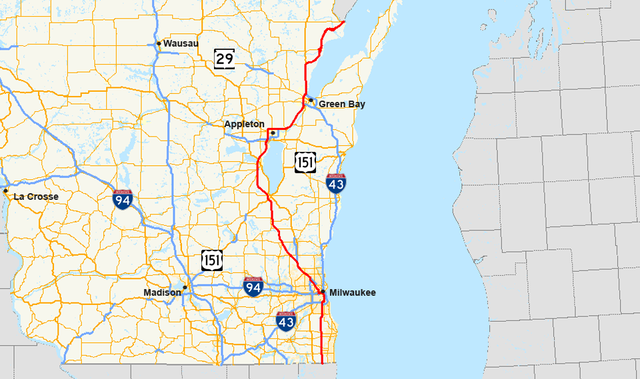
English: Map of U.S. Route 41 in Wisconsin |
| Date | |
| Source | Own work (Highway information: National Highway Planning Network Data; Geographic information: TIGER Data Shapefiles) |
| Author | User: Master son |

|
This road map image could be re-created using vector graphics as an SVG file. This has several advantages; see Commons:Media for cleanup for more information. If an SVG form of this image is available, please upload it and afterwards replace this template with
{{vector version available|new image name}}.
It is recommended to name the SVG file “US-41-(WI)-map.svg”—then the template Vector version available (or Vva) does not need the new image name parameter. |
Licensing
|


-map.png)
File history
Click on a date/time to view the file as it appeared at that time.
| Date/Time | Thumbnail | Dimensions | User | Comment | |
|---|---|---|---|---|---|
| current | 02:32, 14 January 2009 | | 960 × 569 (338 KB) | Master son | == Summary == {{Information |Description={{en|1=Map of w:U.S. Route 41 in Wisconsin}} |Source=Own work (Highway information: [http://www.fhwa.dot.gov/planning/nhpn/ National Highway Planning Network Data]; Geographic information: [http://www.esri.co |
File usage
No pages on the English Wikipedia use this file (pages on other projects are not listed).
Global file usage
The following other wikis use this file:
- Usage on de.wikipedia.org
- Usage on www.wikidata.org
-map.png)