
File:US23 cut at Pound Gap.jpg

Size of this preview: 800 × 532 pixels. Other resolutions: 320 × 213 pixels | 640 × 426 pixels | 1,024 × 681 pixels | 1,280 × 851 pixels | 2,560 × 1,702 pixels | 6,016 × 4,000 pixels.
Original file (6,016 × 4,000 pixels, file size: 6.37 MB, MIME type: image/jpeg)
| This is a file from the Wikimedia Commons. Information from its description page there is shown below. Commons is a freely licensed media file repository. You can help. |
| Camera location | | View this and other nearby images on: OpenStreetMap |
|---|
| Description |
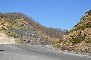
English: Looking westward along U.S. Route 23 into the main cut atop Pound Gap, a mountain pass in the Cumberland Mountains of the United States. Photo is taken in Wise County, Virginia, while the more distant areas of the picture are part of Letcher County, Kentucky. |
||
| Date | Taken on 21 April 2014 | ||
| Source | Own work | ||
| Author | Nyttend | ||
| Permission (Reusing this file) |
|
File history
Click on a date/time to view the file as it appeared at that time.
| Date/Time | Thumbnail | Dimensions | User | Comment | |
|---|---|---|---|---|---|
| current | 12:07, 27 April 2014 | | 6,016 × 4,000 (6.37 MB) | Nyttend | {{Location|37|9|18|N|82|37|59|W}} {{Information |Description={{e|Looking westward along {{w|U.S. Route 27}} into the main cut atop {{w|Pound Gap}}, a mountain pass in the {{w|Cumberland Mountains}} of the {{w|United States}}. Photo is taken in {{w|Wis... |
File usage
The following pages on the English Wikipedia use this file (pages on other projects are not listed):
Global file usage
The following other wikis use this file:
- Usage on fr.wikipedia.org
- Usage on ko.wikipedia.org
- Usage on www.wikidata.org