
File:US 10 map.png

Size of this preview: 800 × 466 pixels. Other resolutions: 320 × 186 pixels | 640 × 373 pixels | 1,024 × 597 pixels | 1,280 × 746 pixels | 2,288 × 1,333 pixels.
Original file (2,288 × 1,333 pixels, file size: 90 KB, MIME type: image/png)
| This is a file from the Wikimedia Commons. Information from its description page there is shown below. Commons is a freely licensed media file repository. You can help. |
Summary
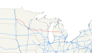
| Description | Map of U.S. Route 10 (the section over Lake Michigan is a ferry). |
| Date | |
| Source | Own work |
| Author | Nick Nolte |
| Permission (Reusing this file) |
Public Domain |
Licensing
I, the copyright holder of this work, hereby publish it under the following license:
| This file is made available under the Creative Commons CC0 1.0 Universal Public Domain Dedication. | |
| The person who associated a work with this deed has dedicated the work to the public domain by waiving all of their rights to the work worldwide under copyright law, including all related and neighboring rights, to the extent allowed by law. You can copy, modify, distribute and perform the work, even for commercial purposes, all without asking permission.
|
File history
Click on a date/time to view the file as it appeared at that time.
| Date/Time | Thumbnail | Dimensions | User | Comment | |
|---|---|---|---|---|---|
| current | 04:42, 21 May 2018 | | 2,288 × 1,333 (90 KB) | Howpper | Updated; Ferry is officially part of the highway. |
| 02:34, 29 August 2006 |  | 2,288 × 1,333 (73 KB) | Stratosphere | ||
| 04:21, 1 July 2006 |  | 2,128 × 1,286 (54 KB) | Stratosphere | ||
| 06:44, 30 June 2006 |  | 1,022 × 617 (23 KB) | Stratosphere | {{Information |Description=Map of U.S. Route 10 |Source=Own Work |Date=June 30, 2006 |Author=Nick Nolte |Permission=Public Domain }} |
File usage
No pages on the English Wikipedia use this file (pages on other projects are not listed).
Global file usage
The following other wikis use this file:
- Usage on de.wikipedia.org
- Usage on it.wikipedia.org
- Usage on ko.wikipedia.org
- Usage on pt.wikipedia.org
- Usage on ru.wikipedia.org
- Usage on sv.wikipedia.org
- Usage on th.wikipedia.org
- Usage on uk.wikipedia.org
- Usage on www.wikidata.org
- Usage on zh.wikipedia.org