
File:US Geological Provinces.gif
Size of this preview: 800 × 497 pixels. Other resolutions: 320 × 199 pixels | 640 × 398 pixels | 1,190 × 740 pixels.
Original file (1,190 × 740 pixels, file size: 195 KB, MIME type: image/gif, 0.1 s)
| This is a file from the Wikimedia Commons. Information from its description page there is shown below. Commons is a freely licensed media file repository. You can help. |
Summary
| Description |
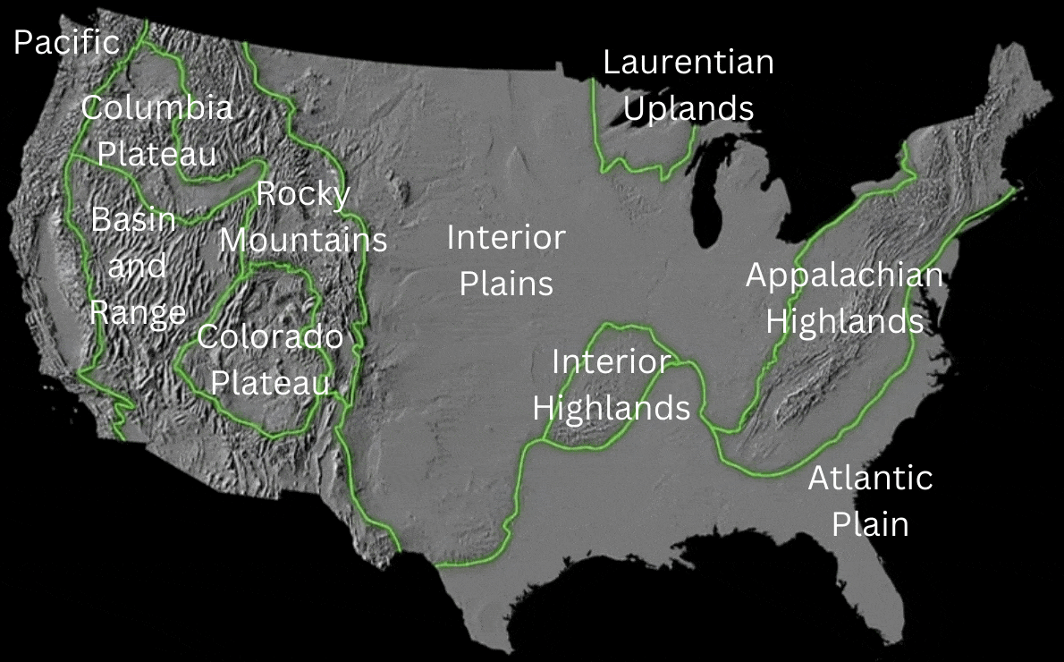
English: Map of U.S. Geological Provinces. Relief map and outline from USGS, labels added by Hike395 at English Wikipedia |
| Date | |
| Source | Original map |
| Author |
|
| Other versions | Lower-resolution png version |
Licensing
This image is in the public domain in the United States because it only contains materials that originally came from the United States Geological Survey, an agency of the United States Department of the Interior. For more information, see the official USGS copyright policy.
|
labels, AI upscaling:
| This file is made available under the Creative Commons CC0 1.0 Universal Public Domain Dedication. | |
| The person who associated a work with this deed has dedicated the work to the public domain by waiving all of their rights to the work worldwide under copyright law, including all related and neighboring rights, to the extent allowed by law. You can copy, modify, distribute and perform the work, even for commercial purposes, all without asking permission.
|
File history
Click on a date/time to view the file as it appeared at that time.
| Date/Time | Thumbnail | Dimensions | User | Comment | |
|---|---|---|---|---|---|
| current | 18:15, 17 December 2023 | | 1,190 × 740 (195 KB) | Hike395 | redo text on top of scaled background image |
| 17:51, 23 September 2023 |  | 1,256 × 744 (183 KB) | Hike395 | == {{int:filedesc}} == {{Information |Description={{en|1=Map of U.S. Geological Provinces. Relief map and outline from USGS, labels added by {{User at project|Hike395|wikipedia|en}}}} |Source={{Derived from|US Geological Provinces.png|display=50}} |Date=2023-09-23 17:50 (UTC) |Author=* File:US Geological Provinces.png: USGS * labels, AI upscaling: [[User:{{subst:REVISIONUSER}}|{{subst:REVISIONUSER}}]] |Permission= |other_versions= }} == {{int:license-hea... |
File usage
The following pages on the English Wikipedia use this file (pages on other projects are not listed):