
File:United Kingdom EU referendum 2016 area results 2-tone.svg

Size of this PNG preview of this SVG file: 405 × 599 pixels. Other resolutions: 162 × 240 pixels | 324 × 480 pixels | 519 × 768 pixels | 692 × 1,024 pixels | 1,384 × 2,048 pixels | 871 × 1,289 pixels.
Original file (SVG file, nominally 871 × 1,289 pixels, file size: 4.66 MB)
| This is a file from the Wikimedia Commons. Information from its description page there is shown below. Commons is a freely licensed media file repository. You can help. |
Summary
| Description |
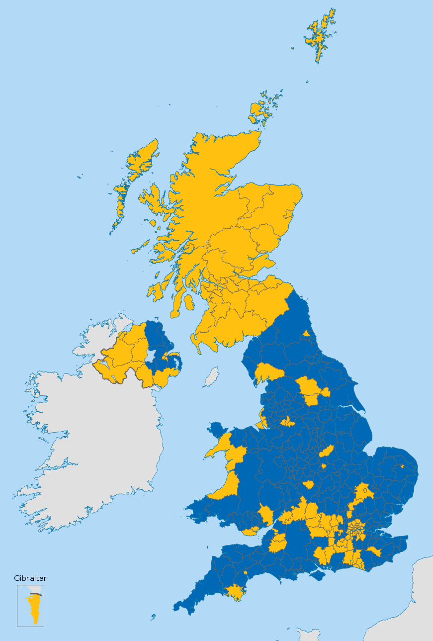
English (en): Map of the United Kingdom showing the voting areas for the European Union membership referendum, 2016.
Leave Remain
|
| Date | |
| Source |
This vector image includes elements that have been taken or adapted from this file: This vector image includes elements that have been taken or adapted from this file: This vector image includes elements that have been taken or adapted from this file: This vector image includes elements that have been taken or adapted from this file: This vector image includes elements that have been taken or adapted from this file: |
| Author |
Mirrorme22 Nilfanion: English and Scottish council areas TUBS: Welsh council areas Sting: Gibraltar |
| Other versions |
 |
| SVG development |
Licensing
This file is licensed under the Creative Commons Attribution-Share Alike 3.0 Unported license.
- You are free:
- to share – to copy, distribute and transmit the work
- to remix – to adapt the work
- Under the following conditions:
- attribution – You must give appropriate credit, provide a link to the license, and indicate if changes were made. You may do so in any reasonable manner, but not in any way that suggests the licensor endorses you or your use.
- share alike – If you remix, transform, or build upon the material, you must distribute your contributions under the same or compatible license as the original.
File history
Click on a date/time to view the file as it appeared at that time.
| Date/Time | Thumbnail | Dimensions | User | Comment | |
|---|---|---|---|---|---|
| current | 20:09, 25 July 2016 | | 871 × 1,289 (4.66 MB) | Cranberry Products | fixed Horsham and Havant |
| 19:06, 24 June 2016 |  | 871 × 1,289 (4.66 MB) | Nilfanion | Reverted, dark boundary lines please - white is jarring | |
| 19:04, 24 June 2016 |  | 871 × 1,289 (4.66 MB) | EmmaCoop | Wrong upload | |
| 17:54, 24 June 2016 |  | 871 × 1,289 (4.66 MB) | EmmaCoop | Set boundaries to #fff | |
| 09:08, 24 June 2016 |  | 871 × 1,289 (4.66 MB) | Nilfanion | fix Carms | |
| 07:42, 24 June 2016 |  | 871 × 1,289 (4.66 MB) | Nilfanion | full results | |
| 01:13, 24 June 2016 |  | 871 × 1,289 (4.66 MB) | Nilfanion | =={{int:filedesc}}== {{Information |description={{en|1=Map of the United Kingdom showing the voting areas for the European Union membership referendum, 2016.}} |date=2016-02-20 |source={{AttribSVG|Scottish council areas 2011.svg|Nilfanion}}{{AttribSVG|... |
File usage
The following pages on the English Wikipedia use this file (pages on other projects are not listed):
- 2016 United Kingdom European Union membership referendum
- Aftermath of the 2016 United Kingdom European Union membership referendum
- Brexit
- European Union Referendum Act 2015
- Political history of the United Kingdom (1979–present)
- Referendums in the United Kingdom
- Results of the 2016 United Kingdom European Union membership referendum
- United Kingdom membership of the European Union
- Talk:2016 United Kingdom European Union membership referendum/Archive 2
- Talk:2016 United Kingdom European Union membership referendum/Archive 3
- Wikipedia:In the news/Candidates/June 2016
- Template:UKEU2016Results
Global file usage
The following other wikis use this file:
- Usage on als.wikipedia.org
- Usage on an.wikipedia.org
- Usage on ast.wikipedia.org
- Usage on bat-smg.wikipedia.org
- Usage on br.wikipedia.org
- Usage on ca.wikipedia.org
- Usage on ckb.wikipedia.org
- Usage on cy.wikipedia.org
- Usage on da.wikipedia.org
- Usage on de.wikipedia.org
- Usage on el.wikipedia.org
- Usage on eml.wikipedia.org
- Usage on eo.wikipedia.org
- Usage on es.wikipedia.org
- Usage on et.wikipedia.org
- Usage on eu.wikipedia.org
- Usage on fi.wikipedia.org
- Usage on fr.wikipedia.org
- Usage on gl.wikipedia.org
- Usage on id.wikipedia.org
- Usage on it.wikipedia.org
- Usage on jv.wikipedia.org
- Usage on ko.wikipedia.org
- Usage on li.wikipedia.org
- Usage on lt.wikipedia.org
- Usage on lv.wikipedia.org
- Usage on nl.wikipedia.org
- Usage on no.wikipedia.org
- Usage on pt.wikipedia.org
- Usage on ro.wikipedia.org
View more global usage of this file.