
File:United States Highway 61 Arch, AR-MO state line.jpg

Size of this preview: 800 × 450 pixels. Other resolutions: 320 × 180 pixels | 640 × 360 pixels | 1,024 × 576 pixels | 1,280 × 720 pixels | 2,816 × 1,584 pixels.
Original file (2,816 × 1,584 pixels, file size: 1.16 MB, MIME type: image/jpeg)
| This is a file from the Wikimedia Commons. Information from its description page there is shown below. Commons is a freely licensed media file repository. You can help. |
|
This is an image of a place or building that is listed on the National Register of Historic Places in the United States of America. Its reference number is 01001177. |
| Camera location | | View this and other nearby images on: OpenStreetMap |
|---|
| Description |
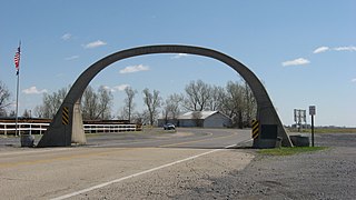
English: View from the west of the United States Highway 61 Arch, located over U.S. Route 61 between Steele and Blytheville on the Arkansas/Missouri border in the United States. Built in 1922, it is listed on the National Register of Historic Places. |
||
| Date | Taken on 12 April 2013 | ||
| Source | Own work | ||
| Author | Nyttend | ||
| Permission (Reusing this file) |
|
File history
Click on a date/time to view the file as it appeared at that time.
| Date/Time | Thumbnail | Dimensions | User | Comment | |
|---|---|---|---|---|---|
| current | 17:16, 19 April 2013 | | 2,816 × 1,584 (1.16 MB) | Nyttend | {{NRHP|01001177}} {{Location|35|59|58.3|N|89|53|53.8|W}} {{Information |Description={{en|View from the west of the {{w|United States Highway 61 Arch}}, located over {{w|U.S. Route 61}} between {{w|Steele, Missouri|Steele}} and {{w|Blytheville, Arkansas... |
File usage
The following pages on the English Wikipedia use this file (pages on other projects are not listed):
Global file usage
The following other wikis use this file:
- Usage on de.wikipedia.org
- Usage on www.wikidata.org