
File:Verbreitungskarte Mainzer Rad 2.png

Size of this preview: 800 × 581 pixels. Other resolutions: 320 × 232 pixels | 640 × 465 pixels | 1,024 × 743 pixels | 1,280 × 929 pixels | 1,500 × 1,089 pixels.
Original file (1,500 × 1,089 pixels, file size: 672 KB, MIME type: image/png)
| This is a file from the Wikimedia Commons. Information from its description page there is shown below. Commons is a freely licensed media file repository. You can help. |
Summary
|
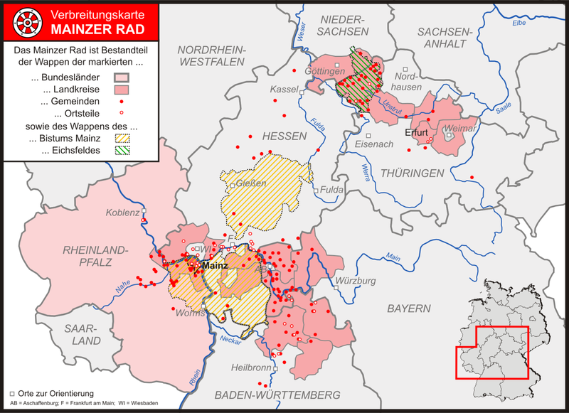
| Description | Bundesländer, Landkreise, Städte/Gemeinden und Stadtteile/Ortsteile mit dem Mainzer Rad im Wappen |
| Date | |
| Source |
"own work", used: |
| Author | Lencer |

|
This map has been made or improved in the German Kartenwerkstatt (Map Lab). You can propose maps to improve as well.
|
Licensing
The map has been created with the Generic Mapping Tools: https://www.generic-mapping-tools.org/ using one or more of these public-domain datasets for the relief:
|

|
Permission is granted to copy, distribute and/or modify this document under the terms of the GNU Free Documentation License, Version 1.2 or any later version published by the Free Software Foundation; with no Invariant Sections, no Front-Cover Texts, and no Back-Cover Texts. A copy of the license is included in the section entitled GNU Free Documentation License. |
| This file is licensed under the Creative Commons Attribution-Share Alike 3.0 Unported license. | ||
| ||
| This licensing tag was added to this file as part of the GFDL licensing update. |
File history
Click on a date/time to view the file as it appeared at that time.
| Date/Time | Thumbnail | Dimensions | User | Comment | |
|---|---|---|---|---|---|
| current | 15:48, 4 August 2007 | | 1,500 × 1,089 (672 KB) | Lencer | |
| 12:44, 4 August 2007 |  | 1,500 × 1,088 (672 KB) | Lencer | ||
| 11:26, 4 August 2007 |  | 1,500 × 1,089 (664 KB) | Lencer | ||
| 10:51, 4 August 2007 |  | 1,500 × 1,088 (664 KB) | Lencer | ||
| 10:47, 4 August 2007 |  | 2,326 × 3,127 (1.24 MB) | Lencer | ||
| 18:06, 3 August 2007 |  | 1,500 × 1,088 (659 KB) | Lencer | ||
| 17:38, 3 August 2007 |  | 1,500 × 1,088 (666 KB) | Lencer | ||
| 15:41, 3 August 2007 |  | 1,500 × 1,088 (659 KB) | Lencer | {{Information |Description= Bundesländer, Landkreise, Städte/Gemeinden und Stadteile/Ortsteile mit dem Mainzer Rad im Wappen |Source="own work", used: * [[:Image:Karte Bundesrepublik Deutschland.svg|Karte Bundesrepublik Deutschland] |
File usage
The following pages on the English Wikipedia use this file (pages on other projects are not listed):
Global file usage
The following other wikis use this file:
- Usage on cs.wikipedia.org
- Usage on de.wikipedia.org
- Mainzer Rad
- Portal:Frankfurt Rhein-Main/Vitrine
- Portal:Wappen
- Benutzer:Lencer
- Benutzer:Lencer/Galerie
- Portal:Mainz
- Portal:Mainz/Ausgezeichnete Artikel
- Wikipedia:Exzellente Bilder/Karten und Satellitenbilder
- Portal:Rheinhessen
- Portal:Rheinhessen/Ausgezeichnete Artikel
- Wikipedia:Kartenwerkstatt/Archiv/2007-08
- Wikipedia:Kandidaten für exzellente Bilder/Archiv2007/12
- Datei:Verbreitungskarte Mainzer Rad 2.png
- Liste der Wappen mit dem Mainzer Rad
- Benutzer:Lencer/Unterseite
- Wikipedia:Kartenwerkstatt/Archiv/2009-08
- Wikipedia:Eine-Million-Artikel-Seite
- Wikipedia:Eine-Million-Artikel-Seite/Dateien
- Wikipedia:Kartenwerkstatt/Archiv/2010-03
- Wikipedia:Kartenwerkstatt/Schaufenster
- Wikipedia:Kartenwerkstatt/Archiv/2012-12
- Wikipedia:Kartenwerkstatt/Archiv/Zurückgewiesene und zurückgestellte Aufträge 2016
- Wikipedia:Exzellente Bilder/Kleine Bilder
- Usage on fr.wikipedia.org
- Usage on it.wikipedia.org
- Usage on uk.wikipedia.org