
File:WW2 pillbox at Freewarren Bridge near Crofton - geograph.org.uk - 800994.jpg
No higher resolution available.
WW2_pillbox_at_Freewarren_Bridge_near_Crofton_-_geograph.org.uk_-_800994.jpg (640 × 426 pixels, file size: 97 KB, MIME type: image/jpeg)
| This is a file from the Wikimedia Commons. Information from its description page there is shown below. Commons is a freely licensed media file repository. You can help. |
Summary
| Description |
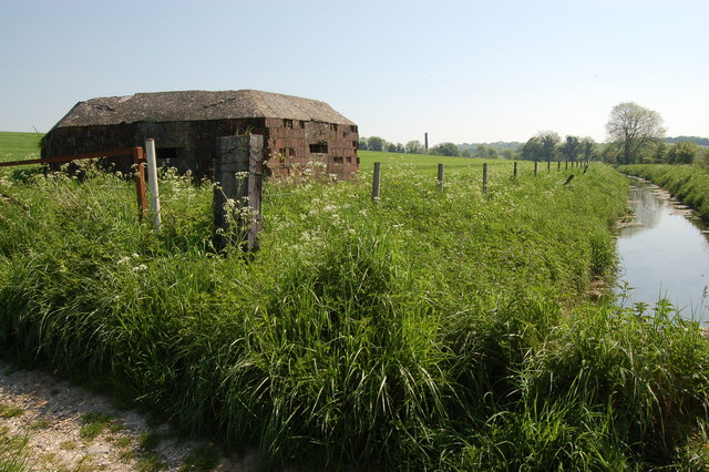
English: WW2 pillbox at Freewarren Bridge near Crofton This type FW3/22 pillbox stands close to Freewarren Bridge and to the north of a drainage ditch (seen here), the main railway line and the Kennet & Avon Canal. Originally, the pillbox was one of one hundred and seventy built hastily in 1940 to create 'GHQ stop-line Blue' running for 58 miles between Bradford-on-Avon and Tilehurst. The view looks eastwards and the chimney of Crofton pumping station can be seen in the background. |
| Date | |
| Source | From geograph.org.uk |
| Author | Roger Davies |
| Attribution (required by the license) | Roger Davies / WW2 pillbox at Freewarren Bridge near Crofton / |
| Camera location | | View this and other nearby images on: OpenStreetMap |
|---|
_heading:67.00&language=en)
| Object location | | View this and other nearby images on: OpenStreetMap |
|---|
_heading:67.00&language=en)
Licensing

|
This image was taken from the Geograph project collection. See this photograph's page on the Geograph website for the photographer's contact details. The copyright on this image is owned by Roger Davies and is licensed for reuse under the Creative Commons Attribution-ShareAlike 2.0 license.
|
This file is licensed under the Creative Commons Attribution-Share Alike 2.0 Generic license.
Attribution: Roger Davies
- You are free:
- to share – to copy, distribute and transmit the work
- to remix – to adapt the work
- Under the following conditions:
- attribution – You must give appropriate credit, provide a link to the license, and indicate if changes were made. You may do so in any reasonable manner, but not in any way that suggests the licensor endorses you or your use.
- share alike – If you remix, transform, or build upon the material, you must distribute your contributions under the same or compatible license as the original.
File history
Click on a date/time to view the file as it appeared at that time.
| Date/Time | Thumbnail | Dimensions | User | Comment | |
|---|---|---|---|---|---|
| current | 10:17, 20 February 2011 | | 640 × 426 (97 KB) | GeographBot | == {{int:filedesc}} == {{Information |description={{en|1=WW2 pillbox at Freewarren Bridge near Crofton This type FW3/22 pillbox stands close to Freewarren Bridge and to the north of a drainage ditch (seen here), the main railway line and the Kennet & Avon |
File usage
The following pages on the English Wikipedia use this file (pages on other projects are not listed):
Global file usage
The following other wikis use this file:
- Usage on de.wikipedia.org
- Usage on es.wikipedia.org
- Usage on fr.wikipedia.org
- Usage on it.wikipedia.org
- Usage on nl.wikipedia.org
- Usage on www.wikidata.org