
File:Waterperry Gardens - geograph.org.uk - 1484616.jpg
No higher resolution available.
Waterperry_Gardens_-_geograph.org.uk_-_1484616.jpg (640 × 480 pixels, file size: 78 KB, MIME type: image/jpeg)
| This is a file from the Wikimedia Commons. Information from its description page there is shown below. Commons is a freely licensed media file repository. You can help. |
Summary
| Description |
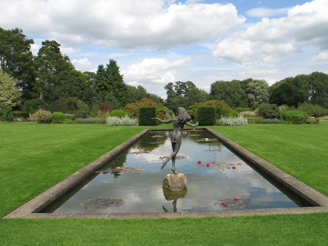
English: Waterperry Gardens The village of Waterperry lies 7 miles (11 km) east of Oxford on the border with Buckinghamshire. Waterperry House is the former home of the Curzon and Henley families, representatives of which lie in the adjacent private grave-yard. The House, which stands in 8 acres of attractive gardens, is a hybrid of architectural styles; originally a 17th century mansion, it was remodelled in the 18th and 19th centuries.
The Waterlily Canal, shown here, is studded with jewel-like waterlilies including varieties like James Brydon, Escarboucle, Gladstoniana, Texas Dawn, Cromatella, Perry's Pink. The statue of Miranda from Shakespeare's The Tempest, sculptured by Tanya Russel surveys the scene. |
| Date | |
| Source | From geograph.org.uk |
| Author | Ian Petticrew |
| Camera location | | View this and other nearby images on: OpenStreetMap |
|---|
_heading:45.00&language=en)
| Object location | | View this and other nearby images on: OpenStreetMap |
|---|
_heading:45.00&language=en)
Licensing

|
This image was taken from the Geograph project collection. See this photograph's page on the Geograph website for the photographer's contact details. The copyright on this image is owned by Ian Petticrew and is licensed for reuse under the Creative Commons Attribution-ShareAlike 2.0 license.
|
This file is licensed under the Creative Commons Attribution-Share Alike 2.0 Generic license.
Attribution: Ian Petticrew
- You are free:
- to share – to copy, distribute and transmit the work
- to remix – to adapt the work
- Under the following conditions:
- attribution – You must give appropriate credit, provide a link to the license, and indicate if changes were made. You may do so in any reasonable manner, but not in any way that suggests the licensor endorses you or your use.
- share alike – If you remix, transform, or build upon the material, you must distribute your contributions under the same or compatible license as the original.
File history
Click on a date/time to view the file as it appeared at that time.
| Date/Time | Thumbnail | Dimensions | User | Comment | |
|---|---|---|---|---|---|
| current | 15:41, 2 March 2011 | | 640 × 480 (78 KB) | GeographBot | == {{int:filedesc}} == {{Information |description={{en|1=Waterperry Gardens The village of Waterperry lies 7 miles (11 km) east of Oxford on the border with Buckinghamshire. Waterperry House is the former home of the Curzon and Henley families, represent |
File usage
The following pages on the English Wikipedia use this file (pages on other projects are not listed):
Global file usage
The following other wikis use this file:
- Usage on cs.wikipedia.org