
File:West Bassett Stamps - geograph.org.uk - 353846.jpg
No higher resolution available.
West_Bassett_Stamps_-_geograph.org.uk_-_353846.jpg (640 × 426 pixels, file size: 117 KB, MIME type: image/jpeg)
| This is a file from the Wikimedia Commons. Information from its description page there is shown below. Commons is a freely licensed media file repository. You can help. |
Summary
| Description |
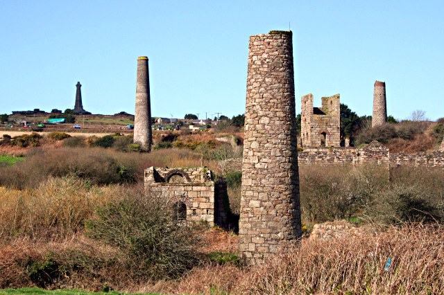
English: West Basset Stamps This is the remains of the buildings which housed machinery to crush, grade and concentrate the ore to make it ready for sale. On the horizon at the top of Carn Brea Hill is the De Dunstanville Memorial, a memorial to one of the Bassett family. The Bassetts were big landowners hereabouts in the 19th century. Landowners were just about the only people who were guaranteed to get rich from mining as they took a percentage of everything sold without having to invest a penny in any mines on their land. |
| Date | |
| Source | From geograph.org.uk |
| Author | Tony Atkin |
| Camera location | | View this and other nearby images on: OpenStreetMap |
|---|
_heading:0.00&language=en)
| Object location | | View this and other nearby images on: OpenStreetMap |
|---|
_heading:0.00&language=en)
Licensing

|
This image was taken from the Geograph project collection. See this photograph's page on the Geograph website for the photographer's contact details. The copyright on this image is owned by Tony Atkin and is licensed for reuse under the Creative Commons Attribution-ShareAlike 2.0 license.
|
This file is licensed under the Creative Commons Attribution-Share Alike 2.0 Generic license.
Attribution: Tony Atkin
- You are free:
- to share – to copy, distribute and transmit the work
- to remix – to adapt the work
- Under the following conditions:
- attribution – You must give appropriate credit, provide a link to the license, and indicate if changes were made. You may do so in any reasonable manner, but not in any way that suggests the licensor endorses you or your use.
- share alike – If you remix, transform, or build upon the material, you must distribute your contributions under the same or compatible license as the original.
File history
Click on a date/time to view the file as it appeared at that time.
| Date/Time | Thumbnail | Dimensions | User | Comment | |
|---|---|---|---|---|---|
| current | 20:21, 2 January 2011 | | 640 × 426 (117 KB) | GeographBot | == {{int:filedesc}} == {{Information |description={{en|1=West Bassett Stamps This is the remains of the buildings which housed machinery to crush, grade and concentrate the ore to make it ready for sale. On the horizon at the top of Carn Brea Hill is the |
File usage
The following pages on the English Wikipedia use this file (pages on other projects are not listed):
Global file usage
The following other wikis use this file:
- Usage on www.wikidata.org