
File:Weston-super-Mare, Worlebury hillfort - geograph.org.uk - 134707.jpg
No higher resolution available.
Weston-super-Mare,_Worlebury_hillfort_-_geograph.org.uk_-_134707.jpg (640 × 427 pixels, file size: 208 KB, MIME type: image/jpeg)
| This is a file from the Wikimedia Commons. Information from its description page there is shown below. Commons is a freely licensed media file repository. You can help. |
Summary
| Description |
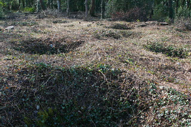
English: Weston-super-Mare: Worlebury hillfort. Recent tree clearance of part of the 10-acre site, in the hands of North Somerset Council, has revealed some of the 93 storage pits first discovered in the 1850s, when the site was excavated by a group of antiquarians. Grain was found in a number of the pits, which are unusually large at 6 to 8 feet in diameter and typically 6 feet deep. For a good guide to the hillfort, see Worlebury. The story of the Iron Age hill-fort at Weston-super-Mare, obtainable from Woodspring Museum, Burlington Street, Weston-super-Mare BS23 1PR. Phone 01934 612006 |
| Date | |
| Source | From geograph.org.uk |
| Author | Martin Bodman |
| Attribution (required by the license) | Martin Bodman / Weston-super-Mare: Worlebury hillfort / |
| Object location | | View this and other nearby images on: OpenStreetMap |
|---|
_&language=en)
Licensing

|
This image was taken from the Geograph project collection. See this photograph's page on the Geograph website for the photographer's contact details. The copyright on this image is owned by Martin Bodman and is licensed for reuse under the Creative Commons Attribution-ShareAlike 2.0 license.
|
This file is licensed under the Creative Commons Attribution-Share Alike 2.0 Generic license.
Attribution: Martin Bodman
- You are free:
- to share – to copy, distribute and transmit the work
- to remix – to adapt the work
- Under the following conditions:
- attribution – You must give appropriate credit, provide a link to the license, and indicate if changes were made. You may do so in any reasonable manner, but not in any way that suggests the licensor endorses you or your use.
- share alike – If you remix, transform, or build upon the material, you must distribute your contributions under the same or compatible license as the original.
File history
Click on a date/time to view the file as it appeared at that time.
| Date/Time | Thumbnail | Dimensions | User | Comment | |
|---|---|---|---|---|---|
| current | 07:34, 31 January 2010 | | 640 × 427 (208 KB) | GeographBot | == {{int:filedesc}} == {{Information |description={{en|1=Weston-super-Mare: Worlebury hillfort. Recent tree clearance of part of the 10-acre site, in the hands of North Somerset Council, has revealed some of the 93 storage pits first discovered in the 185 |
File usage
The following pages on the English Wikipedia use this file (pages on other projects are not listed):
Global file usage
The following other wikis use this file:
- Usage on ar.wikipedia.org
- Usage on da.wikipedia.org
- Usage on de.wikipedia.org
- Usage on no.wikipedia.org