
File:Wien - ehemalige Böhmische Hofkanzlei.JPG

Size of this preview: 800 × 460 pixels. Other resolutions: 320 × 184 pixels | 640 × 368 pixels | 1,024 × 589 pixels | 1,280 × 736 pixels | 2,560 × 1,473 pixels | 4,606 × 2,650 pixels.
Original file (4,606 × 2,650 pixels, file size: 9.41 MB, MIME type: image/jpeg)
| This is a file from the Wikimedia Commons. Information from its description page there is shown below. Commons is a freely licensed media file repository. You can help. |
Summary
| Description |
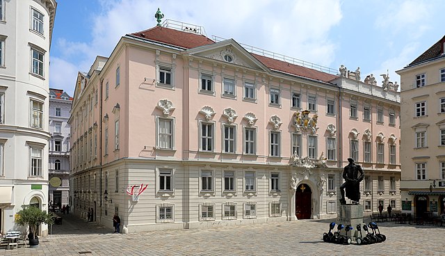
Deutsch: Die Südwestecke der ehemaligen Böhmischen Hofkanzlei im 1. Wiener Gemeindebezirk Innere Stadt und davor das Lessing-Denkmal.
Das Gebäude zwischen dem Judenplatz und der Wipplinger Straße wurde von 1708/09 bis 1714 nach einem Entwurf von Johann Bernhard Fischer von Erlach erbaut und von 1751 bis 1754 von Mathias Gerl erweitert. Aktuell (2018) beherbergt es den Verwaltungsgerichtshof. |
| Date | |
| Source | Own work |
| Author | C.Stadler/Bwag |
| Permission (Reusing this file) |
Deutsch: Hallo, du darfst mein Foto kostenlos nutzen, aber nenne mich bitte als Fotograf, beispielsweise „Foto: C.Stadler/Bwag“ oder © C.Stadler/Bwag; CC-BY-SA-4.0. Auf mehr Angaben bestehe ich nicht - im Gegensatz zu manch anderen, die die Vorgaben der unten angeführten Lizenzierung auf Punkt und Beistrich einfordern. English: Feel free to use my photos, but please mention me as the author like © C.Stadler/Bwag or © C.Stadler/Bwag; CC-BY-SA-4.0 (that's good enough) and if you want send me a message: bwag@gmx.net. |
| Object location | | View this and other nearby images on: OpenStreetMap |
|---|
| Camera location | | View this and other nearby images on: OpenStreetMap |
|---|
Licensing
I, the copyright holder of this work, hereby publish it under the following license:
This file is licensed under the Creative Commons Attribution-Share Alike 4.0 International license.
- You are free:
- to share – to copy, distribute and transmit the work
- to remix – to adapt the work
- Under the following conditions:
- attribution – You must give appropriate credit, provide a link to the license, and indicate if changes were made. You may do so in any reasonable manner, but not in any way that suggests the licensor endorses you or your use.
- share alike – If you remix, transform, or build upon the material, you must distribute your contributions under the same or compatible license as the original.
File history
Click on a date/time to view the file as it appeared at that time.
| Date/Time | Thumbnail | Dimensions | User | Comment | |
|---|---|---|---|---|---|
| current | 16:49, 19 May 2018 | | 4,606 × 2,650 (9.41 MB) | Bwag | {{Information |Description= {{de|1=Die Südwestecke der ehemaligen Böhmischen Hofkanzlei im 1. Wiener Gemeindebezirk Innere Stadt und davor das Lessing-Denkmal.<br/>Das Gebäude zwischen dem de:JudenplatzJohann Bernhard Fischer von Erlach erbaut und von 1751 bis 1754 von Mathias Gerl erweitert. Aktuell (2018) beherbergt es den [[:de:Verwaltungsgerichtshof (Österr... |
File usage
The following pages on the English Wikipedia use this file (pages on other projects are not listed):
Global file usage
The following other wikis use this file:
- Usage on cs.wikipedia.org
- Usage on da.wikipedia.org
- Usage on de.wikipedia.org
- Politisches System Österreichs
- Verfassungsgerichtshof (Österreich)
- Verwaltungsgerichtshof (Österreich)
- Österreich
- Böhmische Hofkanzlei
- Vorarlberger Landesverfassung
- Fütterergasse
- Wikipedia:WikiProjekt Österreich/WD/Innere Stadt
- Liste der böhmischen Oberstkanzler
- Wikipedia:WikiProjekt Österreich/checks/Denkmalschutz/WP - WD diffs 08
- Usage on de.wikivoyage.org
- Usage on es.wikipedia.org
- Usage on fr.wikipedia.org
- Usage on fy.wikipedia.org
- Usage on hu.wikipedia.org
- Usage on hy.wikipedia.org
- Usage on ka.wikipedia.org
- Usage on nl.wikipedia.org
- Usage on ru.wikipedia.org
- Usage on sh.wikipedia.org
- Usage on sv.wikipedia.org
- Usage on uk.wikipedia.org
- Usage on www.wikidata.org
- Usage on zh.wikipedia.org