
File:Winterthur Battle 1799.svg

Size of this PNG preview of this SVG file: 506 × 599 pixels. Other resolutions: 203 × 240 pixels | 405 × 480 pixels | 648 × 768 pixels | 864 × 1,024 pixels | 1,729 × 2,048 pixels | 845 × 1,001 pixels.
Original file (SVG file, nominally 845 × 1,001 pixels, file size: 426 KB)
| This is a file from the Wikimedia Commons. Information from its description page there is shown below. Commons is a freely licensed media file repository. You can help. |
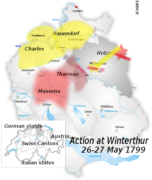
| Description | District of Winterthur Map drawn by Tschubby |
| Date | (UTC) |
| Source |
Own work using:
|
| Author |
|
| This is a retouched picture, which means that it has been digitally altered from its original version. Modifications: added location of battle outside Winterthur, May 1799. The original can be viewed here: Karte Bezirk Winterthur.png:
|
I, the copyright holder of this work, hereby publish it under the following licenses:
| This file is licensed under the Creative Commons Attribution-Share Alike 3.0 Unported license. | ||
| ||
| This licensing tag was added to this file as part of the GFDL licensing update. |

|
Permission is granted to copy, distribute and/or modify this document under the terms of the GNU Free Documentation License, Version 1.2 or any later version published by the Free Software Foundation; with no Invariant Sections, no Front-Cover Texts, and no Back-Cover Texts. A copy of the license is included in the section entitled GNU Free Documentation License. |
You may select the license of your choice.
Original upload log
This image is a derivative work of the following images:
- File:Karte_Bezirk_Winterthur.png licensed with Cc-by-sa-3.0-migrated, GFDL
- 2005-06-15T18:08:08Z Tschubby 826x1001 (259741 Bytes) District of Winterthur Map drawn by [[:de:Benutzer:Tschubby|Tschubby]] [[Category:Maps of Canton of Zurich|Winterthur]] {{GFDL}}
Uploaded with derivativeFX
File history
Click on a date/time to view the file as it appeared at that time.
| Date/Time | Thumbnail | Dimensions | User | Comment | |
|---|---|---|---|---|---|
| current | 22:00, 3 February 2010 | | 845 × 1,001 (426 KB) | Auntieruth55 | fix size. |
| 21:51, 3 February 2010 |  | 765 × 1,260 (425 KB) | Auntieruth55 | added location map, geographic info, etc. | |
| 19:46, 3 February 2010 |  | 765 × 1,260 (365 KB) | Auntieruth55 | Reverted to version as of 19:43, 3 February 2010 | |
| 19:45, 3 February 2010 |  | 765 × 1,260 (365 KB) | Auntieruth55 | added location map | |
| 19:43, 3 February 2010 |  | 765 × 1,260 (365 KB) | Auntieruth55 | Clarified location, added location map, additional markers, changed illustration of movements. | |
| 10:41, 13 January 2010 |  | 826 × 1,001 (354 KB) | Fundriver | Reverted to version as of 10:34, 13 January 2010 | |
| 10:41, 13 January 2010 |  | 826 × 1,001 (354 KB) | Fundriver | ... | |
| 10:34, 13 January 2010 |  | 826 × 1,001 (354 KB) | Fundriver | "Schaffhausen" erased (this is a map of the canton of Zurich). | |
| 03:26, 29 December 2009 |  | 826 × 1,001 (355 KB) | Auntieruth55 | {{Information |Description=District of Winterthur Map drawn by Tschubby |Source=*File:Karte_Bezirk_Winterthur.png |Date=2009-12-29 03:22 (UTC) |Author=*File:Karte_Bezirk_Winterthur.png: Tschubby *de |
File usage
The following pages on the English Wikipedia use this file (pages on other projects are not listed):
Global file usage
The following other wikis use this file:
- Usage on es.wikipedia.org
- Usage on fa.wikipedia.org
- Usage on hr.wikipedia.org
- Usage on id.wikipedia.org
- Usage on uz.wikipedia.org
- Usage on zh.wikipedia.org