
File:Yemen Warmap with Frontlines.png

Size of this preview: 800 × 522 pixels. Other resolutions: 320 × 209 pixels | 640 × 418 pixels | 1,024 × 668 pixels | 1,280 × 835 pixels | 2,560 × 1,670 pixels | 3,199 × 2,087 pixels.
Original file (3,199 × 2,087 pixels, file size: 620 KB, MIME type: image/png)
| This is a file from the Wikimedia Commons. Information from its description page there is shown below. Commons is a freely licensed media file repository. You can help. |
Summary
| Description |
Dansk: Borgerkrigen i Yemen, der started I 2015.
Kontrolleret af Houthierne.
Kontrolleret af Abd Rabbuh Mansur Hadis regering.
Kontrolleret af ”Southern Transitional Council” (Den Sydlige Bevægelse).
Kontrolleret af Ansar al-Sharia/AQAP som er relateret til al-Qaeda.
Kontrolleret af Islamisk Stat. Deutsch: Detaillierte Karte des Bürgerkriegs im Jemen
Kontrolliert durch die Huthi
Kontrolliert durch Anhänger von Abed Rabbo Mansur Hadi
Kontrolliert durch die Südliche Bewegung
Kontrolliert durch Al-Qaida auf der arabischen Halbinsel
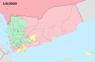
Kontrolliert durch den Islamischen Staat English: Insurgency in Yemen detailed Map according to published reports. This map's information is sometimes based on w:Module:Yemeni Civil War detailed map. For sources, see that page's history and talk page. For a visual representation of the data, see that module's documentation page.
Controlled by Revolutionary Committee
Controlled by Hadi-led government
Controlled by Southern Transitional Council
Controlled by Ansar al-Sharia/AQAP forces
Controlled by the Islamic State of Iraq and the Levant (ISIL) Español: Mapa detallado de la insurgencia en Yemen
Controlado por el Comité Revolucionario
Controlado por el Gobierno liderado por Hadi
Controlado por Ansar al-Sharia/AQPA forces
Controlado por el Estado Islámico de Irak y el Levante (ISIL) Français : Conflit au Yémen, d'après une carte de Mark Monmonier
Territoire contrôlé par les loyalistes
Territoire contrôlé par les Houthis
Territoire contrôlé par les djihadistes d'AQPA et de l'EI au Yémen
Territoire contrôlé par le Conseil de transition du Sud Italiano: Mappa dettagliata della situazione attuale in Yemen
Controllato dal w:it:Comitato Rivoluzionario
Controllato dalle truppe di w:it:Abd Rabbuh Mansur al-Hadi
Controllato da w:it:Ansar al-Sharia forces
Controllato dallo w:it:Stato Islamico Ελληνικά: Η κατάσταση στον Υεμενικό Εμφύλιο Πόλεμο, όπως έχει διαμορφωθεί σύμφωνα με δημοσιεύματα.
Περιοχή ελεγχόμενη από την Επαναστατική Επιτροπή
Περιοχή ελεγχόμενη από την κυβέρνηση Χάντι και το Νότιο Κίνημα
Περιοχή ελεγχόμενη από δυνάμεις των οργανώσεων Ανσάρ αλ-Σαρία/Αλ Κάιντα
Περιοχή ελεγχόμενη από το Ισλαμικό Κράτος Русский: Подробная карта мятежа в Йемене
Под контролем Ансар Аллах
Под контролем Правительства Хади в изгнании
Под контролем Южного Переходного Совета
Под контролем Аль-Каиды на Аравийском полуострове
Под контролем Исламского государства Ирака и Леванта (ИГИЛ) 한국어: 예멘 반란 상세지도
예멘 정부 통치 하의 지역
후티 반군과 살레정부군 통치 하의 지역
남예멘 분리주의자(남부과도위원회) 통치 하의 지역
알카에다 통치 하의 지역
이슬람 국가(ISIL) 통치 하의 지역 اردو : یمنی خاناجنگی کی صورتحال
حوثی باغیوں اور علی عبدالله صالح کے حامیوں کے قبضے میں
صابق صدر، منصور ہادی کے حامیوں کے قبضے میں
القاعدہ کے قبضے میں العربية : النزاع في اليمنː
تحت سيطرة الحوثيون والجيش المؤيد لعلي عبد الله صالح
تسيطر عليها حكومة الرئيس عبد ربه منصور هادي
تحت سيطرة القاعدة وأنصار الشريعة
تحت سيطرة w:ar:المجلس الانتقالي الجنوبي فارسی : نقشهٔ جزئیات درگیریهای جنگ داخلی یمن
در دست انصارالله
در دست نیروهای هوادار منصور هادی
در دست القاعده یا انصارالشریعه (وفادار به داعش)
در دست مجلس انتقالی جنوب |
| Date | |
| Source | Own work |
| Author | TheMapLurker |
Licensing
I, the copyright holder of this work, hereby publish it under the following license:
This file is licensed under the Creative Commons Attribution-Share Alike 4.0 International license.
- You are free:
- to share – to copy, distribute and transmit the work
- to remix – to adapt the work
- Under the following conditions:
- attribution – You must give appropriate credit, provide a link to the license, and indicate if changes were made. You may do so in any reasonable manner, but not in any way that suggests the licensor endorses you or your use.
- share alike – If you remix, transform, or build upon the material, you must distribute your contributions under the same or compatible license as the original.
File history
Click on a date/time to view the file as it appeared at that time.
| Date/Time | Thumbnail | Dimensions | User | Comment | |
|---|---|---|---|---|---|
| current | 11:02, 1 June 2020 | | 3,199 × 2,087 (620 KB) | Borysk5 | Removed AQAP-held area from Hadramaut district - as I explained in talk page of Module, government has since 2016 recaptured all territories there. |
| 06:23, 19 April 2020 |  | 2,771 × 1,805 (743 KB) | Mr. James Dimsey | New image. | |
| 02:34, 8 April 2020 |  | 3,210 × 2,803 (965 KB) | TheMapLurker | Uploaded own work with UploadWizard |
File usage
The following pages on the English Wikipedia use this file (pages on other projects are not listed):
Global file usage
The following other wikis use this file:
- Usage on ar.wikipedia.org
- Usage on pnb.wikipedia.org
- Usage on ru.wikipedia.org
- Usage on ur.wikipedia.org