
HarbourFront MRT station
NE1 CC29 HarbourFront 港湾 துறைமுகம் | ||||||||||||||||||||||||||||||||||||||||||||||||||||||||||||||||||||||||||||||||||||||
|---|---|---|---|---|---|---|---|---|---|---|---|---|---|---|---|---|---|---|---|---|---|---|---|---|---|---|---|---|---|---|---|---|---|---|---|---|---|---|---|---|---|---|---|---|---|---|---|---|---|---|---|---|---|---|---|---|---|---|---|---|---|---|---|---|---|---|---|---|---|---|---|---|---|---|---|---|---|---|---|---|---|---|---|---|---|---|
| Mass Rapid Transit (MRT) interchange and terminus | ||||||||||||||||||||||||||||||||||||||||||||||||||||||||||||||||||||||||||||||||||||||
 Exit D of HarbourFront MRT station | ||||||||||||||||||||||||||||||||||||||||||||||||||||||||||||||||||||||||||||||||||||||
| General information | ||||||||||||||||||||||||||||||||||||||||||||||||||||||||||||||||||||||||||||||||||||||
| Location | 81 Telok Blangah Road Singapore 098867[1] | |||||||||||||||||||||||||||||||||||||||||||||||||||||||||||||||||||||||||||||||||||||
| Coordinates | 01°15′55″N 103°49′20″E / 1.26528°N 103.82222°E | |||||||||||||||||||||||||||||||||||||||||||||||||||||||||||||||||||||||||||||||||||||
| Operated by | SBS Transit Ltd (ComfortDelGro Corporation) (North East line) SMRT Trains Ltd (SMRT Corporation) (Circle line) | |||||||||||||||||||||||||||||||||||||||||||||||||||||||||||||||||||||||||||||||||||||
| Line(s) | ||||||||||||||||||||||||||||||||||||||||||||||||||||||||||||||||||||||||||||||||||||||
| Platforms | 4 (2 island platforms) | |||||||||||||||||||||||||||||||||||||||||||||||||||||||||||||||||||||||||||||||||||||
| Tracks | 4 | |||||||||||||||||||||||||||||||||||||||||||||||||||||||||||||||||||||||||||||||||||||
| Connections | HarbourFront Bus Interchange, Sentosa Express, Taxi | |||||||||||||||||||||||||||||||||||||||||||||||||||||||||||||||||||||||||||||||||||||
| Construction | ||||||||||||||||||||||||||||||||||||||||||||||||||||||||||||||||||||||||||||||||||||||
| Structure type | Underground | |||||||||||||||||||||||||||||||||||||||||||||||||||||||||||||||||||||||||||||||||||||
| Platform levels | 1 | |||||||||||||||||||||||||||||||||||||||||||||||||||||||||||||||||||||||||||||||||||||
| Parking | Yes (VivoCity, HarbourFront Centre) | |||||||||||||||||||||||||||||||||||||||||||||||||||||||||||||||||||||||||||||||||||||
| Bicycle facilities | Yes | |||||||||||||||||||||||||||||||||||||||||||||||||||||||||||||||||||||||||||||||||||||
| Accessible | Yes | |||||||||||||||||||||||||||||||||||||||||||||||||||||||||||||||||||||||||||||||||||||
| History | ||||||||||||||||||||||||||||||||||||||||||||||||||||||||||||||||||||||||||||||||||||||
| Opened | 20 June 2003 (North East line) 8 October 2011 (Circle line) | |||||||||||||||||||||||||||||||||||||||||||||||||||||||||||||||||||||||||||||||||||||
| Electrified | Yes | |||||||||||||||||||||||||||||||||||||||||||||||||||||||||||||||||||||||||||||||||||||
| Previous names | World Trade Centre | |||||||||||||||||||||||||||||||||||||||||||||||||||||||||||||||||||||||||||||||||||||
| Services | ||||||||||||||||||||||||||||||||||||||||||||||||||||||||||||||||||||||||||||||||||||||
| ||||||||||||||||||||||||||||||||||||||||||||||||||||||||||||||||||||||||||||||||||||||
| ||||||||||||||||||||||||||||||||||||||||||||||||||||||||||||||||||||||||||||||||||||||
| Location | ||||||||||||||||||||||||||||||||||||||||||||||||||||||||||||||||||||||||||||||||||||||
_map.svg) HarbourFront HarbourFront station in Singapore | ||||||||||||||||||||||||||||||||||||||||||||||||||||||||||||||||||||||||||||||||||||||
HarbourFront MRT station is an underground Mass Rapid Transit (MRT) interchange station in Singapore. The termini of the North East line (NEL) and Circle line (CCL), the station serves the HarbourFront area and Sentosa. Surrounding retail and commercial developments include VivoCity and HarbourFront Centre, and the station is near HarbourFront Bus Interchange and the Singapore Cruise Centre.
The NEL station was first announced as World Trade Centre MRT station in March 1996 as one of the line's 16 stations. Its construction involved several road diversions and the opening of the drainage culverts. The NEL station was completed on 20 June 2003. The CCL platforms opened on 8 October 2011 along with Stages 4 and 5 of the line.
Reflecting the station's location by the Singapore Strait, the station concourse has an elliptical motif resembling a ship hull. The station features three artworks as part of the Art-in-Transit programme. The NEL platforms and concourse display a series of line-drawings by Ian Woo, while the CCL platforms feature Commuting Waves by Jason Ong and a set of art seats entitled Matrix.
History[edit]
North East line[edit]


In preliminary studies for the North East line (NEL) in 1986, it was planned for the line to terminate at Outram Park station, rather than HarbourFront.[2] In a later study in 1995, the planned NEL was extended to serve World Trade Centre.[3] After plans for the new line were approved by the government in January 1996,[4] the station, then tentatively named World Trade Centre, was among the 16 NEL stations announced by communications minister Mah Bow Tan in March 1996.[5]
The contract for constructing the station and tunnels was awarded to Hyundai Engineering & Construction at S$132.8 million (US$143 million in 2022) in September 1997.[6] The scope of the contract included the widening of a section of Telok Blangah Road.[7] The new station was expected to boost retail and residential developments in the Telok Blangah area, which was known for the Keppel Harbour and associated industries. The Port of Singapore Authority (PSA) had cooperated with the Land Transport Authority (LTA) officials on redevelopment plans for the area.[8] To minimise impact on businesses in the area, the contractor used silent pilers when driving steel piles into the ground. These pilers created less noise and vibrations compared to conventional pilers.[7]
The station was constructed near the seashore. In order to prevent water seepage into the site, the contractors injected cement into the soil surrounding the station site via jet grouting. Sheet piles were installed around the site, and tests were conducted to determine the amount of saltwater and groundwater at the site. The contractor initially considered rerouting the drainage system that channelled water to the sea but that was financially unfeasible. Instead, the culverts that crossed the site were cut open and diverted into temporary steel culverts or pipes that did not obstruct the works.[9] Due to the limited space, two of the World Trade Centre's exhibition halls were demolished to facilitate construction works.[10]
Concurrently, the Telok Blangah Road was being upgraded with a new vehicular overpass being constructed.[9] Hence, the LTA's road and rail project teams had to coordinate to maximise the efficiency of both projects. The rail project team had constructed 10 viaduct foundations for the road section that crosses the station site. At the same time, the contractor had to maintain the traffic flow in the area – not just for visitors to the World Trade Centre, but to prevent delays and disruptions to port operations nearby. The traffic was diverted to temporary steel decking that ran over the construction site. The roads were diverted at least 30 times for the station's construction.[10]
The contractors (Shimira Corporation, Koh Brothers, Dillingham Construction International) for the 2.16-kilometre (1.34 mi) of tunnelling works between this station and the adjacent Outram Park station had to monitor for any ground movement for the shophouses and ensure operations for the Malaysian rail service was not affected. A dual-mode tunnel boring machine was used to deal with the varying soil conditions along the tunnel route.[11]
HarbourFront station opened on 20 June 2003 with the rest of the NEL stations.[12][13] In October 2012, the LTA announced that the NEL overrun tunnel would be extended by 50 metres (160 ft). Completed at the end of 2014 at a cost of S$8.2 million (US$6.6 million), the extension is to facilitate quicker turnarounds for southbound trains.[14]
As part of a joint emergency preparedness exercise by the LTA and train operators SBS Transit and SMRT, security screenings were held at the station on 2 August 2019.[15] The screening machines deployed for the exercise include mass screening devices and X-Ray machines to check for possible threat items like firearms. Such exercises were conducted to test established response protocols and maintain vigilance for quicker and more effective responses during emergencies and heightened security situations.[16]
Circle line[edit]

In 2001, Yeo Cheow Tong, the communications minister, announced that the Circle line (CCL) will serve the HarbourFront area.[17][18] On 12 December 2003, the LTA confirmed that HarbourFront station will interchange with the CCL and the new platforms would be constructed as part of CCL Stage 5 (CCL5).[19] This segment consisted of five stations from West Coast station to this station.[20]
The contract for the fitting out works for the CCL station and connecting tunnels was awarded to SembCorp Engineers & Constructors Pte Ltd (SembCorp E&C) at S$335.38 million (US$198.7 million) in October 2004.[21] The contract include civil, architectural and building works for the West Coast, Pasir Panjang, Alexandra and Telok Blangah stations, alongside 3.4 kilometres (2.1 mi) of twin bored tunnels and 640 metres (700 yd) of cut and cover tunnels.[22]
To facilitate construction works for the CCL platforms, Platform A of the NEL station was closed on 30 October 2005. Trains on the NEL from Punggol station terminated at Outram Park station, while a special shuttle train was launched for services between Outram Park and HarbourFront.[23] In December 2009, structure works for the CCL station were completed, with backfilling in progress.[24] As announced by transport minister Lui Tuck Yew during his visit to the CCL4 and 5 stations on 1 August 2011,[25][26] the CCL platforms began revenue service on 8 October that year.[27][28]
On 17 January 2013, transport minister Lui Tuck Yew announced that the CCL would be extended from HarbourFront station to Marina Bay station as part of CCL Stage 6.[29] Tunnelling works between this station and Keppel station began on 25 July 2019,[30] and were completed in August 2020.[31]
Station details[edit]
_20220214_181950.jpg)
HarbourFront station is the terminus of the NEL and CCL; its official station code is NE1/CC29. On the NEL, the adjacent station is Outram Park station. Trains turnaround by using the cripple siding on the west end of the station or the crossover on the east end of the station. The next stop on the CCL in the clockwise direction is Telok Blangah station.[32] Trains turnaround on the CCL terminus by using crossovers located at both ends of the station. With the completion of CCL6, the subsequent station in the counterclockwise direction will be Keppel.[33] Designed by Architects61, the station concourse has an elliptical motif resembling a ship hull, alongside floor patterns and the artwork that reflects the station's location by the Singapore Strait.[7][34]
The station is underneath Telok Blangah Road and has five entrances.[1][35] HarbourFront station serves various commercial and retail developments including HarbourFront Centre and VivoCity.[35] It is the closest MRT station to the tourist island of Sentosa.[36] The station is also near HarbourFront Bus Interchange, Seah Im Food Centre, Singapore Cruise Centre and Mount Faber Park, along with the cultural sites of Temenggong Mosque and St James Power Station.[35][37]
The NEL station is designated as a Civil Defence (CD) shelter.[38][39] It is designed to accommodate at least 7,500 people and can withstand airstrikes and chemical attacks. Equipment essential for the operations in the CD shelter is mounted on shock absorbers to prevent damage during a bombing. When electrical supply to the shelter is disrupted, there are backup generators to keep operations going.[40] The shelter has dedicated built-in decontamination chambers and dry toilets with collection bins that will send human waste out of the shelter.[41]
The NEL and CCL platforms are wheelchair-accessible. A tactile system, consisting of tiles with rounded or elongated raised studs,[42] guides visually impaired commuters through the station,[12][43] with dedicated tactile routes that connect the station entrances to the platforms or between either line's platforms.[44]
Public artworks[edit]
The station displays three artworks as part of the MRT network's Art-in-Transit programme – a showcase of public artworks on the MRT network.[45]
Enigmatic Appearances[edit]

Enigmatic Appearances by Ian Woo is a series of line-drawings depicting various sea creatures, ships and clouds in minimalist style. Painted on 60 blue vitreous enamel wall panels, the work was intended to reflect the station's maritime theme and its location near the port.[45][46] With its "dream-like" quality,[47] the figures are in fragments dispersed throughout the station, allowing commuters in the station to slowly perceive the artwork over time.[48] A set of footprints on the walls at the end of the NEL platforms references the station's role as the terminus of the NEL.[46][48]
Inspirations for the artwork were derived from what Woo captured in his visit to the HarbourFront area. In addition to taking photos of the area, he wrote about his experiences during his trip. Creating the work required him to co-operate with the station's architects, since the LTA intended to integrate art with the station's design. Although Woo was used to working independently, he learnt to articulate his thoughts and intentions with the architectural team, with the help of NEL art coordinator Constance Sheares. The collaboration allowed Woo and the architectural team to have deeper insights into each other's works. While retaining his creative freedom over the work, Woo ensured that the work was compatible with the technical aspects of the station design.[49]
After the architects and the Art Review Panel approved his line drawings, the figures were painted and enlarged. This process took place across two weeks, with some revisions made due to the artist's dissatisfaction with some of the enlarged figures. The black-and-white figures were then coloured in blue at a vitreous enamel factory in England. Travelling to the factory to oversee the production process, Woo also gave further instructions and ensured the colours of the final product come out right.[47]
Commuting Waves[edit]

Displayed on the wall of the CCL platforms near the escalators, Commuting Waves by Jason Ong is a pair of sculptures depicting 3D waveforms.[50][51] The waveforms were derived from commuter traffic at the station, with the positions of the glass 'fins' representing the passenger volume and train frequencies.[52] The work is intended to reflect the rhythm and flow of human activities,[45] which linked the work to the station's location, human values and the MRT system.[53]
The work was created through indeterminacy, inspired by experimental music of John Cage. The inspiration came when Ong was researching soundwaves (waveforms being a distinctive element of the waterfront area), and intended to create the waveforms based on the station's environment. Two assistants recorded the train frequency and passenger traffic on a randomly selected weekday and weekend.[51] The artist noted that the data was only derived from commuters on the NEL, since the CCL was not yet operational when the work was created. Nevertheless, he concluded that the graph shapes would remain similar if he were to include passenger numbers from the CCL.[54]
The graphs had to be transformed into sculptures that are "aesthetically pleasing". The protrusion and spacing of each "fin" were dependent on the passenger traffic and train frequency respectively. Using phase shift, a concept by minimalist composer Steve Reich, the data lines were spaced out from the original graphs. Each alternating frequency was split into different layers that spread across the walls. The eventual shapes of the waveforms were derived from the freehand outlines of the graphs. These outlines were also mirrored to produce the shapes.[54]
The sculptures are in red, which not only reflects the human rhythm but also complements the CCL station's theme, contrasting with the NEL's blue theme. While initially planned to use metal shapes, upon seeing the portfolio of the production team, Ong changed to glass. Ong grouped the fins into sets of six and used serialism to give each fin a different red "tone". The glass used were opaque edged, but as Ong did not like how it appeared, it was changed to transparent edged. An idea to create an illusion of wave moment was discarded due to various unresolved technical difficulties of getting the appropriate tone and colours for the illusion.[53]
Matrix[edit]
The CCL platforms feature a set of "art seats" entitled Matrix. Though the platform seats are intended to be works of art, they are designed to remain functional and practical.[55][56] This work by Lui Honfay and Yasmine Chan, along with Rain, was selected through the International Art Seats Design Competition in 2006.[55] Matrix consists of a series of benches engraved with the station name in a dot-matrix style on the seat surface. The dot-matrix system was adopted as it was flexible enough to be mass-produced for use in many stations. The intriguing combination of signage and seat "impressed" the judges who awarded it the top prize.[57]
References[edit]
- ^ a b "HarbourFront MRT station (NE1/CC29)". OneMap. Singapore Land Authority. Retrieved 16 February 2022.
- ^ "Study on future north-east line". Business Times. Singapore Press Holdings. 26 September 1984. Retrieved 22 August 2021 – via NewspaperSG.
- ^ Leong, Chan Teik (15 July 1995). "North-east MRT line to cost up to $5b". The Straits Times. Singapore Press Holdings. p. 2.
- ^ Leong, Chan Teik (20 January 1996). "Immediate Start for north-east line". The Straits Times. Singapore Press Holdings. p. 1. Archived from the original on 10 December 2021. Retrieved 10 December 2021.
- ^ Leong, Chan Teik (5 March 1996). "16 MRT stations for 20-km North-East line". The Straits Times. Singapore Press Holdings. p. 1.
- ^ "Hyundai clinches $132m MRT deal". Business Times. Singapore Press Holdings. 6 September 1997. p. 9.
- ^ a b c Leong 2003, p. 45.
- ^ Leong 2003, p. 38.
- ^ a b Leong 2003, p. 40.
- ^ a b Leong 2003, p. 42.
- ^ Leong 2003, p. 55.
- ^ a b "North East Line Opens for Passenger Service!". lta.gov.sg. Land Transport Authority. 20 June 2003. Archived from the original on 3 December 2007.
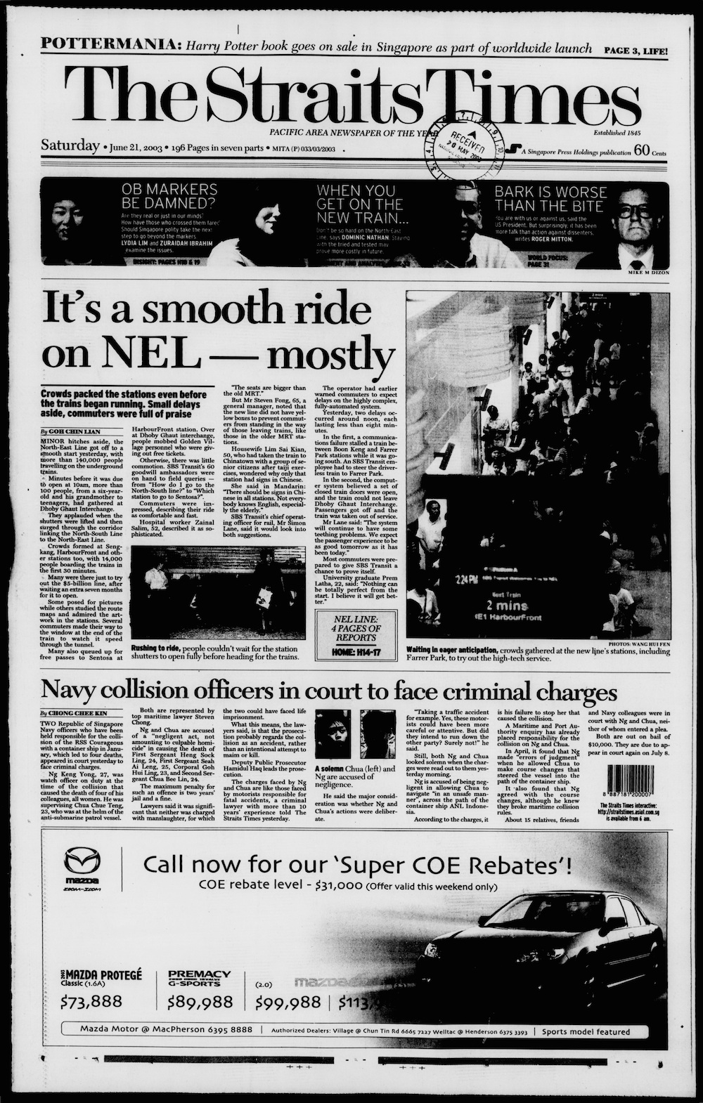
- ^ Goh, Chin Lian (21 June 2003). "It's a smooth ride on NEL – mostly". The Straits Times. Singapore Press Holdings. p. 1. Archived from the original on 10 December 2021. Retrieved 10 December 2021.
Minor hitches aside, the North-East Line got off to a smooth start yesterday
- ^ Sreedharan, Sumita (24 October 2012). "Work on track to speed up NEL service". Channel NewsAsia. Mediacorp. Archived from the original on 25 October 2012. Retrieved 24 October 2012.
- ^ Menon, Malavika (17 July 2019). "MRT commuters at HarbourFront station to undergo screening as part of security exercise on Aug 2". The Straits Times. Singapore Press Holdings. Archived from the original on 10 February 2022. Retrieved 10 February 2022.
- ^ "Joint Release by the Land Transport Authority (LTA), SBS Transit & SMRT – Exercise Station Guard Public Transport Emergency Preparedness Exercise at HarbourFront MRT station". lta.gov.sg. Land Transport Authority. 17 July 2019. Archived from the original on 10 February 2022. Retrieved 10 February 2022.
- ^ "Circle Line and Kallang/Paya Lebar Expressway: Joint Press Statement by Ministry of Communications and Information Technology and Ministry of Law". National Archives of Singapore. Ministry of Information and The Arts. 28 April 2001. Archived from the original on 6 March 2020. Retrieved 10 October 2020.
- ^ Kaur, Karamjit (29 April 2001). "Coming your way – MRT Extension of Marina Line to Upper Paya Lebar Road". The Straits Times. Singapore Press Holdings. p. 1. Archived from the original on 4 December 2021. Retrieved 9 February 2022.
- ^ "Expanding The Rail Network – LTA To Build Circle Line Stages 4 and 5". lta.gov.sg. Land Transport Authority. 12 December 2003. Archived from the original on 19 September 2011. Retrieved 9 February 2022.
- ^ Frances, Joy (13 December 2003). "Completing the Circle via Holland V". Today. Mediacorp. p. 1 – via NewspaperSG.
- ^ "Stages 4 And 5 Of Circle Line". lta.gov.sg. Land Transport Authority. 4 October 2004. Archived from the original on 7 January 2012. Retrieved 9 February 2022.
- ^ "Tender notice". lta.gov.sg. Land Transport Authority. 2 January 2004. Archived from the original on 8 August 2007. Retrieved 9 February 2022.
- ^ "Special Train Service On North East Line Between Outram Park And Harbourfront Stations On 30 October 2005". lta.gov.sg. Land Transport Authority. 28 October 2005. Archived from the original on 19 September 2011. Retrieved 10 February 2022.
- ^ "Circle Line 5 (December 2009)" (PDF). lta.gov.sg. Land Transport Authority. Archived from the original (PDF) on 11 November 2011. Retrieved 10 February 2022.
- ^ "Circle Line from Marymount to HarbourFront to open". mot.gov.sg. Ministry of Transport. 1 August 2011. Archived from the original on 19 November 2020. Retrieved 28 April 2020.
- ^ "12 Circle Line Stations, from Marymount to HarbourFront, to Open on 8 October – Press Room – Land Transport Authority". lta.gov.sg. Land Transport Authority. 1 August 2011. Archived from the original on 17 October 2017. Retrieved 10 February 2022.
- ^ "Speech by Mr Tharman Shanmugaratnam at the Circle Line Opening Ceremony on 7 Oct 2011". mot.gov.sg. Ministry of Transport. 7 October 2011. Archived from the original on 1 May 2020. Retrieved 1 May 2020.
- ^ Almenoar, Maria (8 October 2011). "Circle Line opens on Saturday after 10-year wait". The Straits Times. Singapore Press Holdings. Archived from the original on 25 June 2012. Retrieved 9 February 2022.
- ^ "Speech by Mr Lui Tuck Yew at visit to DTL1 Chinatown Station on 17 January 2013". mot.gov.sg. Ministry of Transport. 17 January 2013. Archived from the original on 28 August 2021. Retrieved 16 April 2022.
- ^ "Joint News Release by the Land Transport Authority (LTA) & SMRT – Upgrading the Circle Line in Preparation for Circle Line 6". lta.gov.sg. Land Transport Authority. 25 July 2019. Archived from the original on 31 October 2020. Retrieved 31 October 2020.
- ^ "Factsheet: Completion of Circle Line 6 Tunnelling Works". lta.gov.sg. Land Transport Authority. 12 January 2022. Archived from the original on 12 January 2022. Retrieved 12 January 2022.
- ^ "MRT System Map" (PDF). lta.gov.sg. Land Transport Authority. Archived (PDF) from the original on 3 September 2021. Retrieved 3 October 2021.
- ^ "Future System Map" (PDF). lta.gov.sg. Land Transport Authority. Archived from the original (PDF) on 9 September 2020. Retrieved 9 September 2020.
- ^ "North East Line: Harbour-Front station". lta.gov.sg. Land Transport Authority. p. 1. Archived from the original on 3 December 2007. Retrieved 16 February 2022.
- ^ a b c "Train Service Information – HarbourFront". SBSTransit. Archived from the original on 16 February 2022. Retrieved 16 February 2022.
- ^ "How to get to Sentosa". sentosa.com.sg. Archived from the original on 13 February 2022. Retrieved 17 February 2022.
- ^ "HarbourFront – Exits". SMRT Journeys. SMRT Corporation. Archived from the original on 8 February 2022. Retrieved 31 December 2021.
- ^ "Chemical attack? Clean-up at N-E line". The Straits Times. Singapore Press Holdings. 14 February 2003.
- ^ "List of Public CD shelters as of 31 Dec 2019" (PDF). Singapore Civil Defence Force. Archived (PDF) from the original on 3 September 2021. Retrieved 3 September 2021.
- ^ Leong 2003, p. 253.
- ^ "Fancy that, dry toilets grab most interest". The Straits Times. Singapore Press Holdings. 16 February 2003. p. 21.
- ^ "Tactile Guiding System: Studs and Strips to Guide Your Way". Land Transport Authority. 30 July 2021. Archived from the original on 11 September 2021. Retrieved 11 September 2021.
- ^ Leong 2003, p. 248.
- ^ Leong 2003, p. 249.
- ^ a b c "Getting Around – Public Transport – A Better Public Transport Experience – Art in Transit". lta.gov.sg. Land Transport Authority. 7 April 2020. Archived from the original on 21 April 2020. Retrieved 21 April 2020.
- ^ a b "Art-in-Transit". SBSTransit. 15 December 2020. Archived from the original on 21 April 2020. Retrieved 22 December 2020.
- ^ a b Tan 2003, p. 31.
- ^ a b Tan 2003, p. 32.
- ^ Tan 2003, p. 30.
- ^ Martin, Mayo (21 September 2011). "Circle Line Art! The final destination(s)! A sneak peek!". Today. Mediacorp. Archived from the original on 27 December 2011. Retrieved 18 February 2022.
- ^ a b Zhuang 2013, p. 168.
- ^ "Circle Line Art" (PDF). lta.gov.sg. Land Transport Authority. Archived from the original (PDF) on 11 February 2017. Retrieved 19 April 2016.
- ^ a b Zhuang 2013, p. 171.
- ^ a b Zhuang 2013, p. 170.
- ^ a b "Art Is Everywhere". lta.gov.sg. Land Transport Authority. Archived from the original on 1 May 2009. Retrieved 3 May 2009.
- ^ Zhuang 2013, pp. 188, 193.
- ^ Zhuang 2013, pp. 188–189.
Bibliography[edit]
- Cheong, Colin (2012). The Circle Line: Linking All Lines (PDF). Singapore: Land Transport Authority. ISBN 978-981-4342-02-5.
- Leong, Chan Teik (2003). Getting there: The story of the North East Line. Singapore: Land Transport Authority. ISBN 981-04-5886-X. OCLC 53383062.
- Tan, Su (2003). Art in transit: North East Line MRT. Singapore: Land Transport Authority. ISBN 981-04-7384-2. OCLC 52771106.
- Zhuang, Justin (2013). Art in transit: Circle Line MRT. Singapore: Land Transport Authority. ISBN 978-981-07-4982-8. OCLC 854958677.
External links[edit]
 Media related to HarbourFront MRT Station at Wikimedia Commons
- SBS Transit's HarbourFront MRT station official website
- SMRT's HarbourFront MRT station official website
- Changi Airport to HarbourFront MRT station Route Map
Italicised locations are currently not in operation | |||||
| North East Line |
| ||||
| Circle Line |
| ||||
| Depot(s) | |||||